Read more …Overview

[ui!] ECOMAT - Allgemeine Geschäfts- und Nutzungsbedingungen

1. Geltungsbereich

1.1. Diese Bedingungen gelten für die Nutzung der [ui!] ECOMAT App der Urban Software Institute GmbH (im Folgenden „[ui!]“ genannt), die über den Google Play Store zum Download bereitgestellt wird. Sie regeln das Vertragsverhältnis zwischen [ui!] und volljährigen Personen, die die App nutzen (im Folgenden "Nutzer" genannt).

1.2. Die Mitarbeiter von [ui!] sind nicht berechtigt, von diesen Bedingungen abweichende Vereinbarungen, Nebenabreden, individuelle Garantiezusagen oder Zusicherungen zu treffen, es sei denn, sie sind hierzu ausdrücklich bevollmächtigt oder kraft ihrer Organstellung, Prokura oder allgemeiner Handlungsvollmacht berechtigt.

1.3. Da die App über Google Play Store zum Download bereitgestellt wird, gelten für den Nutzer unabhängig von diesen Bedingungen ergänzend die Allgemeinen Geschäfts- und Nutzungsbedingungen des App Stores.

1.4. Soweit [ui!] dem Nutzer nach den vertraglichen Bestimmungen Leistungen eines Dritten verschafft, gelten hinsichtlich dieser Leistungen ergänzend die Geschäftsbedingungen des Dritten, sofern sich der Nutzer von diesen vor Vertragsschluss in zumutbarer Weise Kenntnis verschaffen konnte.

1.5. Die Nutzung der App richtet sich sowohl an Verbraucher i.S.d. § 13 BGB als auch an Unternehmer im Sinne von § 14 BGB, d. h. natürliche oder juristische Personen oder rechtsfähige Personengesellschaften, die bei der Nutzung in Ausübung einer gewerblichen oder selbstständigen Tätigkeit handeln.

1.6. Einkaufs- oder Geschäftsbedingungen des Nutzers haben nur Gültigkeit,
 sofern [ui!] diese gesondert schriftlich anerkannt hat. Jedenfalls gilt unter den einzelnen Vereinbarungen folgende Hierarchie der Festlegungen:

    • Änderungen entsprechend Ziffer 1.2.
    • diese Bedingungen
    • Einkaufs- oder Geschäftsbedingungen des Nutzers

Die zuerst genannten Bestimmungen haben bei Widersprüchen oder Unklarheiten stets Vorrang vor den nachfolgend genannten Bestimmungen.


2. Gegenstand des Vertrags / Leistungsumfang

2.1. [ui!] stellt dem Nutzer über Google Play Store eine App zur Verfügung, die Autofahrer bei ihrer Fahrt durch eine Stadt als sogenannter Ampelphasen-Assistent unterstützt und räumt dem Nutzer Nutzungsrechte entsprechend Ziff. 5 ein.

2.2. Dem Nutzer der App werden während der Autofahrt Geschwindigkeitsempfehlungen angezeigt, um ein möglichst sparsames und entspanntes Fahren vor Ampeln (in der Fachsprache "Lichtsignalanlagen") zu fördern. Abhängig von der aktuellen Position, der Geschwindigkeit und dem voraussichtlichen Fahrweg des Fahrzeugs werden Fahrempfehlungen berechnet und über die App ausgegeben. Dazu verwendet die App prognostizierte Grünzeiten der Signalanlagen. Deshalb ist die App an die Datenplattform [ui!] UrbanPulse gekoppelt, die Daten des Verkehrsmanagementsystems einer Stadt erhält und auswertet. Je nach Vereinbarung mit einer Stadt kann der [ui!] ECOMAT-Dienst für bestimmte Strecken oder ein gesamten Stadtnetz betrieben werden.

2.3. Maßgebend für Umfang, Art und Qualität der Leistungen von [ui!] sind die in diesen Bedingungen sowie in etwaigen Dokumentationen z.B. auf der Webseite von [ui!] beschriebenen Leistungen in Bezug auf die [ui!] ECOMAT App.

2.4. Ein Recht des Nutzers auf Einsichtnahme in den Quelltext der App und dessen Überlassung besteht nicht. [ui!] kann insbesondere auch die Einsichtnahme durch Dritte, z.B. Sachverständige im Rahmen eines gerichtlichen Verfahrens, verwehren, wenn die Gefahr besteht, dass hierdurch berechtigte Interessen von [ui!] verletzt werden, insoweit insbesondere die Verletzung von Betriebs- und Geschäftsgeheimnissen droht.

2.5. Produktbeschreibungen, Darstellungen, Dokumentationen und vergleichbare Unterlagen sind Leistungsbeschreibungen, jedoch keine Garantien. Eine Garantie bedarf der schriftlichen Erklärung von [ui!].

2.6. Der Nutzer hat vor Vertragsabschluss überprüft, ob die Spezifikationen des Dienstes, die primär unter Ziff. 2.2 und 3 dieser Bedingungen beschrieben wurden, seinen Wünschen und Bedürfnissen entsprechen. Ihm sind die wesentlichen Funktionsmerkmale und -bedingungen bekannt.

2.7. Die Zurverfügungstellung der App durch [ui!] erfolgt zu Test- und Forschungszwecken
unentgeltlich.

2.8. Der kostenlosen Nutzung der App liegt ein Schenkungsvertrag zugrunde. Die Vorschriften des §§ 516 ff. BGB (Schenkung) finden insoweit ergänzend Anwendung.

Eine Heilung des Mangels einer fehlenden notariellen Beurkundung des Schenkungsversprechens erfolgt durch die Bereitstellung zum Herunterladen der App.


3. Technische Anforderungen für die Nutzung/technische Änderungen der Anforderungen / Verfügbarkeit

3.1. Die aktuelle Version des [ui!] ECOMATs unterstützt Android-basierte Smartphones. Wichtige Anforderungen an geeignete Smartphones sind (Stand Juni 2020):

    • Android Betriebssystem ab Version 6.0
    • Arbeitsspeicher 2GB oder mehr
    • GPS-Modul

3.2. Darüber hinaus fordert die Nutzung der App genügend Akkukapazität des Smartphones sowie eine aktive Internetverbindung, die während der gesamten Fahrt durch das Stadtgebiet zur Verfügung steht.  Für die Erfüllung der technischen Anforderungen ist allein der Nutzer verantwortlich.

3.3. Die Nutzung der App setzt einen Anmeldevorgang voraus. Startet ein Nutzer die App, muss er sich nach dem ersten Start registrieren und hierfür einen ihm bekanntgegebenen Code eingeben. Damit fordert er die Freischaltung an. Sobald er freigeschaltet ist, kann er die App benutzen. Google Play Store ist weder für die Funktionsfähigkeit noch den Support oder die Verfügbarkeit der App verantwortlich.

3.4. Im Rahmen der Anmeldung werden Daten des mobilen Gerätes an Google Play Store sowie an [ui!] übermittelt. Details hierzu können in der Datenschutzerklärung [https://www.ui.city/de/privat-policy] nachgelesen werden.

3.5. Während der Nutzung der App erhebt [ui!] zum Zwecke des technischen Supports, zur Verbesserung der Qualität und des Services sowie zur Forschung anonymisierte Daten. Ist der Nutzer mit dieser Datenverarbeitung nicht einverstanden, muss er die App deaktivieren mit der Folge, dass er den angebotenen Service der [ui!] nicht nutzen kann. Weitergehende Informationen können in der Datenschutzerklärung [https://www.ui.city/de/privat-policy] nachgelesen werden.

3.6. Der Nutzer hat keinen Anspruch auf eine störungsfreie und jederzeit verfügbare Nutzung der kostenlos bereitgestellten App. [ui!] ist in Bezug auf die Verfügbarkeit unter anderem von der Datenplattform [ui!] UrbanPulse abhängig, die Daten des Verkehrsmanagementsystems einer Stadt erhält und auswertet. [ui] hat auf technische Störungen und Ampelausfälle der Stadt keinen Einfluss und übernimmt für die Richtigkeit bzw. Fehlerfreiheit der über die App übertragenen Daten keine Verantwortung.

3.7.  [ui!] behält sich vor, die Anwendbarkeit der App auch auf anderen Betriebssystemen zu erweitern oder Änderungen an der App vorzunehmen. Insoweit können sich auch die Anforderungen für Betriebssysteme ändern und das Herunterladen von Updates erforderlich werden.

3.8. [ui] ist nach vorheriger Ankündigung berechtigt, etwaige zusätzliche Gebühren oder die Einführung der Kostenpflichtigkeit der App mit einer alternativen oder ergänzenden Version des Produktes zu verknüpfen. In diesen Fällen bedarf es der Einbeziehung der zu diesem Zeitpunkt geltenden Allgemeinen Geschäfts- und Nutzungsbedingungen.

3.9. [ui!] behält sich darüber hinaus vor, die Bereitstellung der App jederzeit ohne Angabe von Gründen einzustellen.


4. Nutzungsbedingungen, Sicherheitshinweise und Pflichten des Nutzers

4.1. Der Nutzer darf den Dienst nur im Einklang mit den vertraglichen Vereinbarungen und den gesetzlichen Bestimmungen nutzen. Die kostenlos zur Verfügung gestellte App ist rechtlich geschützt. Das Urheberrecht, Patentrechte, Markenrechte und alle sonstigen Leistungsschutzrechte an der App, die [ui!] dem Nutzer im Rahmen der Vertragsverhältnisses überlässt oder zugänglich macht, stehen im Verhältnis der Vertragspartner ausschließlich [ui!] zu.

Dem Nutzer ist es nicht gestattet, die App, Teile der App oder die Marken von [ui!] in irgendeiner Weise zu kopieren oder zu verändern sowie den Quellcode der Anwendung zu extrahieren. Eine Übersetzung der Anwendung in andere Sprachen sowie abgeleitete Versionen herzustellen ist ebenfalls nicht zulässig.

4.2. Für die Sicherheit und die Beachtung der Verkehrsregeln beim Fahren ist ausschließlich der Fahrer verantwortlich.

4.3. Das Smartphone ist sichtbar auf dem Armaturenbrett oder an der Windschutzscheibe zu montieren, so dass es ohne Mühe während der Fahrt betrachtet werden kann. Eine Bedienung während der Fahrt ist nicht notwendig und nicht erlaubt.

4.4. Allein von Bedeutung ist für den Autofahrer das Signal der Lichtsignalanlage unabhängig von der Anzeige in der App. Die App darf während der Fahrt nicht bedient werden. Für die Bedienung des Smartphones gelten die Anforderungen aus der Straßenverkehrsordnung (StVO).

4.5. Die App dient lediglich dazu, den Autofahrer im Wege eines Ampel-Assistenten über Straßen, die zum Zeitpunkt der Nutzung weniger befahren oder von Grünampelphasen profitieren, zügig ans Ziel zu lotsen und Staustrecken zu vermeiden. Der Autofahrer hat seine Fahrweise stets so anzupassen, dass er andere Straßenverkehrsteilnehmer nicht gefährdet und die Regeln der Straßenverkehrsordnung Beachtung finden.


5. Nutzungsrechte

5.1. Der Nutzer erwirbt mit Vertragsschluss ein zeitlich auf die Dauer der Bereitstellung des Dienstes beschränktes Nutzungsrecht, wobei sich dieses Recht allein darauf beschränkt, die App zu nutzen.

5.2. Eine Installation der neuen Anwendungsversion erfolgt jedoch nicht durch [ui!], sondern muss durch den Nutzer vorgenommen werden. [ui!] informiert insoweit den Nutzer über die Bereitstellung der neuen Programmversion und der Nutzer kann dann die Installation zu einem beliebigen Zeitpunkt vornehmen.


6. Sach- und Rechtsmängelhaftung

6.1. Die Haftung von [ui!]  gegenüber dem Nutzer für Sach- und Rechtsmängel an der überlassenen App ist auf den Fall beschränkt, dass [ui!] gegenüber dem Nutzer einen Fehler an der App bzw. einen Mangel im Recht an der App arglistig verschweigt. In diesem Fall hat [ui!] gem. § 523 Abs.1 BGB bzw. § 524 Abs. 1 BGB dem Nutzer den daraus entstandenen Schaden zu ersetzen.

6.2. Ansprüche des Nutzers auf Mängelbeseitigung durch [ui!]  bestehen bei einer kostenlos überlassenen App nicht.

6.3. Der Nutzer hat [ui!] unverzüglich in Textform zu unterrichten, falls Dritte Schutzrechte (z.B. Urheber- oder Patentrechte) an der App ihm gegenüber geltend machen. Der Nutzer ermächtigt [ui!], die Auseinandersetzung mit dem Dritten allein zu führen. Solange [ui!] von dieser Ermächtigung Gebrauch macht, darf der Nutzer von sich aus die Ansprüche des Dritten nicht ohne Zustimmung von [ui!] anerkennen; [ui!] wehrt dann die Ansprüche des Dritten auf eigene Kosten ab und stellt den Nutzer von allen mit der Abwehr dieser Ansprüche verbundenen Kosten frei, soweit diese nicht auf pflichtwidrigem Verhalten des Nutzers (z.B. der vertragswidrigen Nutzung der App) beruhen.


7. Support und Fehlerbehebung

7.1. [ui] ist bestrebt, Supportleistungen im möglichen Umfang zu erbringen, allerding hat der Nutzer hierauf weder vor Ort, d.h. am Sitz des Nutzers, noch telefonisch oder über elektronische Kontaktmöglichkeiten einen Anspruch hierauf. Gleiches gilt auch für Fehlerbehebungen und die Wiederherstellung der Funktionsfähigkeit der kostenlosen App.


8. Vertragsbeendigung

8.1. Der Nutzer kann das Vertragsverhältnis jederzeit dadurch beenden, dass er die App auf seinem Smartphone deaktiviert.

8.2. Der Einhaltung einer Kündigungsfrist sowie einer Erklärung der Kündigung durch den Nutzer bedarf es nicht.

8.3. [ui!] ist berechtigt, das Vertragsverhältnis durch Einstellung der App ohne Angabe von Gründen zu beenden.


9. Änderung der AGB

9.1. [ui] ist im Falle von Gesetzesänderungen, geänderter Rechtsprechung, bei Änderungen der technischen Anforderungen oder von Funktionalitäten, ferner bei der Einführung einer kostenpflichtigen App berechtigt, die Allgemeinen Geschäfts- und Nutzungsbedingungen jederzeit zu ändern. Aufgrund des besonderen Vertragsverhältnisses bei der Bereitstellung einer kostenlosen App, besteht kein Widerspruchsrecht des Nutzers.


10. Haftung von [ui!]  

10.1. Außerhalb der Sach- und Rechtsmängelhaftung (siehe oben §6) haftet [ui!] gegenüber dem Nutzer nur für vorsätzlich oder grob fahrlässig verursachte Schäden. Die Haftung von [ui!] erstreckt sich auch auf schädigende Handlungen, die auf Vorsatz oder grober Fahrlässigkeit der Vertreter oder Erfüllungsgehilfen von [ui!]  beruhen.

10.2. Eine gesetzlich vorgeschriebene verschuldensunabhängige Haftung von [ui!]  -insbesondere eine Haftung nach Produkthaftungsgesetz - bleibt von den vorstehenden Haftungseinschränkungen unberührt.

10.3. [ui!]  ist berechtigt, Einwände bzgl. eines Mitverschuldens des Nutzers geltend zu machen.


11. Geheimhaltung, Datenschutz

11.1. Die Vertragspartner verpflichten sich, alle ihnen bei der Vertragsdurchführung von dem jeweils anderen Vertragspartner bekannt werdenden Betriebsgeheimnisse des anderen Vertragspartners vertraulich zu behandeln.

11.2. Die zur Abwicklung des Nutzungsverhältnisses erforderlichen Daten des Nutzers werden elektronisch gespeichert. [ui!] verpflichtet sich, die gesetzlichen Bestimmungen zum Datenschutz, insbesondere der EU-DSGVO, dem Bundesdatenschutzgesetz (BDSG) und dem Telemediengesetz (TMG), zu beachten. Weitere Informationen hierzu stellt [ui!] in einer gesonderten Datenschutzerklärung bereit.


12. Leistung durch Dritte

12.1. [ui!]  ist berechtigt, die vertraglich geschuldeten Leistungen durch Dritte, insbesondere durch mit ihr verbundene Unternehmen, zu erbringen.

12.2. [ui!] ist berechtigt, jegliche Ansprüche aus diesem Vertrag an Dritte, insbesondere an mit ihr verbundene Unternehmen, abzutreten oder Dritte zur Geltendmachung im eigenen Namen zu ermächtigen.

12.3. Dem Nutzer ist es untersagt, mit eigenen Forderungen gegenüber [ui!] aufzurechnen, soweit diese Forderungen nicht bestritten oder nicht rechtskräftig festgestellt sind.


13. Allgemeines

13.1. Änderungen und Ergänzungen dieses Vertrags bedürfen der Textform; dies gilt auch für eine Aufhebung dieses Textformerfordernisses.

13.2. Für das Vertragsverhältnis gilt das Recht der Bundesrepublik Deutschland unter Ausschluss des UN-Kaufrechts.

13.3. Sofern der Nutzer Kaufmann, juristische Person des öffentlichen Rechts oder Träger eines öffentlich-rechtlichen Sondervermögens im Sinne des § 38 ZPO ist oder der Nutzer nach Vertragsschluss seinen Wohnsitz, gewöhnlichen Aufenthaltsort oder Firmensitz ins Ausland verlegt oder dieser nicht bekannt ist, ist ausschließlicher Gerichtsstand Chemnitz. Die Gerichte in Chemnitz sind ferner zuständig, wenn der Nutzer keinen allgemeinen Gerichtsstand in Deutschland hat.

13.4. Die Nichtigkeit oder Unwirksamkeit einzelner Bestimmungen dieser Allgemeinen Geschäftsbedingungen berührt die Gültigkeit der übrigen Bestimmungen nicht.


Stand 22.05.2020


Terms & conditions

By downloading or using the app, these terms will automatically apply to you – you should make sure therefore that you read them carefully before using the app. You’re not allowed to copy, or modify the app, any part of the app, or our trademarks in any way. You’re not allowed to attempt to extract the source code of the app, and you also shouldn’t try to translate the app into other languages, or make derivative versions. The app itself, and all the trade marks, copyright, database rights and other intellectual property rights related to it, still belong to Urban Software Institute GmbH.

Urban Software Institute GmbH is committed to ensuring that the app is as useful and efficient as possible. For that reason, we reserve the right to make changes to the app or to charge for its services, at any time and for any reason. We will never charge you for the app or its services without making it very clear to you exactly what you’re paying for.

The Ecomat app stores and processes personal data that you have provided to us, in order to provide our Service. It’s your responsibility to keep your phone and access to the app secure. We therefore recommend that you do not jailbreak or root your phone, which is the process of removing software restrictions and limitations imposed by the official operating system of your device. It could make your phone vulnerable to malware/viruses/malicious programs, compromise your phone’s security features and it could mean that the Ecomat app won’t work properly or at all.

You should be aware that there are certain things that Urban Software Institute GmbH will not take responsibility for. Certain functions of the app will require the app to have an active internet connection. The connection can be Wi-Fi, or provided by your mobile network provider, but Urban Software Institute GmbH cannot take responsibility for the app not working at full functionality if you don’t have access to Wi-Fi, and you don’t have any of your data allowance left.

If you’re using the app outside of an area with Wi-Fi, you should remember that your terms of the agreement with your mobile network provider will still apply. As a result, you may be charged by your mobile provider for the cost of data for the duration of the connection while accessing the app, or other third party charges. In using the app, you’re accepting responsibility for any such charges, including roaming data charges if you use the app outside of your home territory (i.e. region or country) without turning off data roaming. If you are not the bill payer for the device on which you’re using the app, please be aware that we assume that you have received permission from the bill payer for using the app.

Along the same lines, Urban Software Institute GmbH cannot always take responsibility for the way you use the app i.e. You need to make sure that your device stays charged – if it runs out of battery and you can’t turn it on to avail the Service, Urban Software Institute GmbH cannot accept responsibility.

With respect to Urban Software Institute GmbH’s responsibility for your use of the app, when you’re using the app, it’s important to bear in mind that although we endeavour to ensure that it is updated and correct at all times, we do rely on third parties to provide information to us so that we can make it available to you. Urban Software Institute GmbH accepts no liability for any loss, direct or indirect, you experience as a result of relying wholly on this functionality of the app.

At some point, we may wish to update the app. The app is currently available on Android & iOS – the requirements for both systems (and for any additional systems we decide to extend the availability of the app to) may change, and you’ll need to download the updates if you want to keep using the app. Urban Software Institute GmbH does not promise that it will always update the app so that it is relevant to you and/or works with the Android & iOS version that you have installed on your device. However, you promise to always accept updates to the application when offered to you, We may also wish to stop providing the app, and may terminate use of it at any time without giving notice of termination to you. Unless we tell you otherwise, upon any termination, (a) the rights and licenses granted to you in these terms will end; (b) you must stop using the app, and (if needed) delete it from your device.

Changes to This Terms and Conditions

We may update our Terms and Conditions from time to time. Thus, you are advised to review this page periodically for any changes. We will notify you of any changes by posting the new Terms and Conditions on this page. These changes are effective immediately after they are posted on this page.

Contact Us

If you have any questions or suggestions about our Terms and Conditions, do not hesitate to contact us at Diese E-Mail-Adresse ist vor Spambots geschützt! Zur Anzeige muss JavaScript eingeschaltet sein!.

Read more …Terms and Conditions

The best advertising is satisfied customers

Some references


[ui!] UrbanPulse & [ui!] COCKPIT

Open data platform & corresponding visualisation - as the basis for your digitalisation strategy

Weiter Referenzen gerne auf Anfrage...

  This email address is being protected from spambots. You need JavaScript enabled to view it. 

[ui!] Participation in projects

Development of innovative ideas and concepts in consortia of research, technology and application partners

  • FLOBIDAS

    Floating Bike Data Space

    By setting up a bicycle mobility data space (DRM), research and companies are given the opportunity to support cities in the transport transition. With the International Data Space (IDS) approach, both data providers and data recipients have the opportunity to make completely sovereign decisions about the use of the data at any time.

    To the project page

  • ISTBAYERN

    Real-time information system for smart visitor guidance for tourist facilities in Bavaria

    Piloting of an information network that collates and analyses data on visitor movements from various sources and provides (near) real-time information on the current and future capacity utilisation of tourist hotspots in Bavaria.

    To the project page

  • KIWA

    AI-based forest monitoring

    The project aims to utilise innovative technologies such as AI to identify and predict potential forest fire risks, enabling early prevention and intervention measures and coordinating local response teams based on real-time data.

    To the project page

  • KIVEP

    Prevent and detect compromises of IoT devices through protocol anomaly detection

    The aim of the project is to apply protocol anomaly detection methods to the IoT base stations that connect the devices to the Internet via low-energy wireless networks such as LoRaWAN (Long Range Wide Area Network) or NB-IoT (NarrowBand IoT).

    To the project page

  • MoVeToLausitz

    Mobility support by means of data-based traffic management and alternative offers for tourist mobility in Lusatia

    The tourism sector represents enormous potential for strengthening the structure of lignite mining regions in Lusatia that are undergoing change. Unfortunately, the region is facing major challenges in the area of mobility, for which this project aims to find solutions through intelligent, multimodal mobility concepts.

    To the project page

  • OMU

    On holiday with ecological mobility

    The aim of the research project is to develop and test appropriate AI to enable proactive positioning and charge status optimisation of e-vehicles in sharing mode for tourists. The focus is on the necessary data integration based on open data, as well as on testing the business process defined in the use case.

    To the project page

  • Moby dex

    Multimodal Mobility Index

    The Moby Dex project is developing a mobility index that compares supply and demand. Demand is recorded using mobile phone data and FCD, among other things. Moby Dex thus enables the needs-based expansion of sustainable mobility for entire regions. The system is being trialled in the target regions of the Ruhr and Baden-Württemberg.

    To the project page

  • PuR2Scale

    Categorisation of P+R facilities

    The aim of the project is to categorise P+R facilities and thus transfer the results to a large area. With the help of machine learning, a forecasting model will be created for each type of facility that can predict the utilisation of P+R facilities in order to reduce the time users spend searching for a parking space and to facilitate and promote the switch between private and public transport.

    To the project page

  • SDIKA

    Secure Digital Identities Karlsruhe

    The SDIKA project is concerned with the use and testing of secure digital identities. The technology of secure digital identities primarily contributes to digital sovereignty and data security in communication between people and institutions.

    To the project page

  • Smart Region Hub Bad Hersfeld

    Smart Region Exhibition

    An exhibit on the topic of traffic was created for the exhibition at wortreich in Bad Hersfeld. A map of the city with stops for various modes of transport and car and bike sharing locations is displayed on a wooden wall. The visitor's aim is to get from one end of the map to the other. In order to cover this distance, the visitor must follow a continuous path with the help of various chains.

    To the project page

  • STR

    Smart tourism region

    With the real-time data that is now available - i.e. automatically recorded data on car park occupancy and traffic frequency - and with the help of artificial intelligence, forecasts on the utilisation of hotspots and car parks as well as traffic volumes are to be created in future. Guests will then know in advance how busy the local car parks will be over the next few hours. At the same time, attractive alternatives will be suggested.

    To the project page

Further information on projects is available on request...

  This email address is being protected from spambots. You need JavaScript enabled to view it. 

Would you like to learn more about our solutions?

We are also available for demonstrations at our branches in Berlin, Darmstadt, Munich, Walldorf or Chemnitz.

Would you like to learn more about our solutions?

Brief2 This email address is being protected from spambots. You need JavaScript enabled to view it.

Read more …Examples

Alle Fachanwendungen und Informationen
für Ihren Arbeitsplatz auf einen Klick

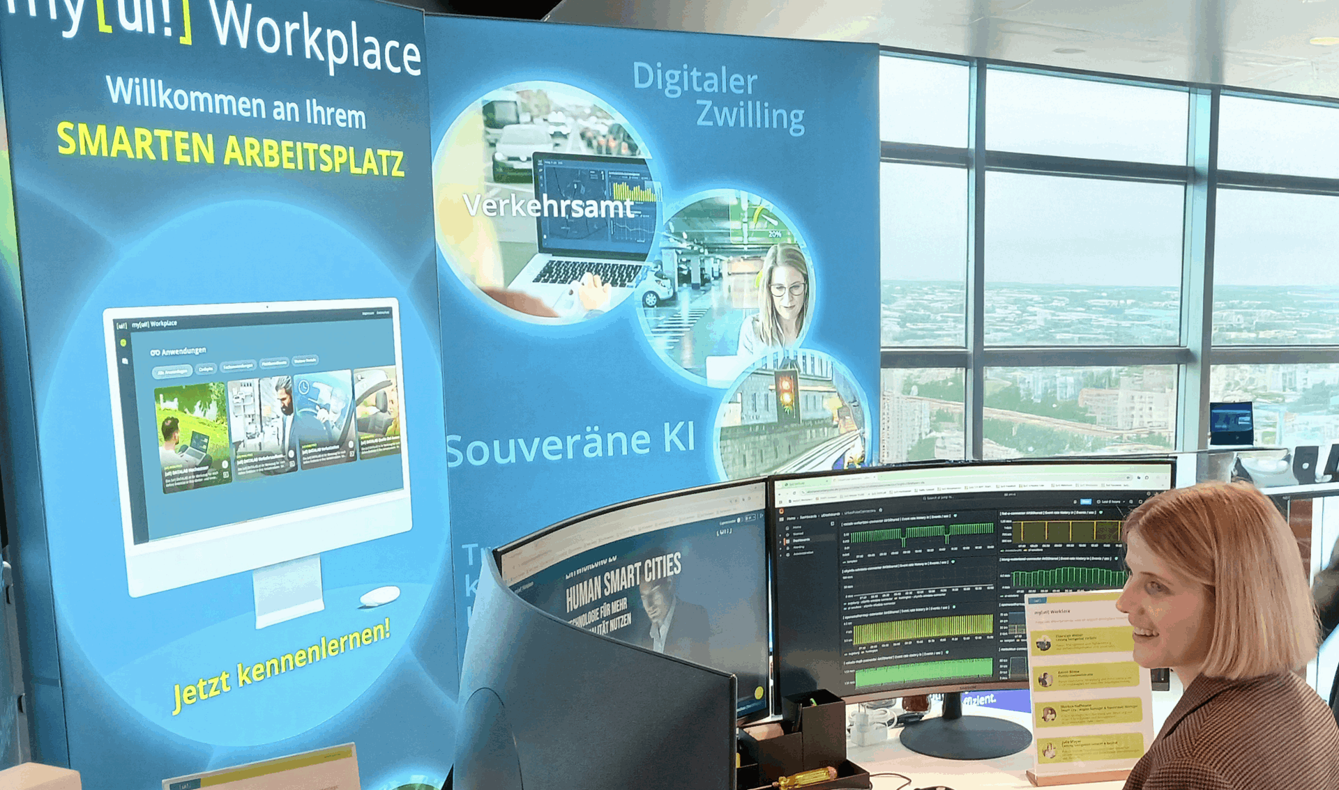
Mit my[ui!] Workplace in die digitale Transformation Ihrer Kommune einsteigen!

Wie wird unsere Kommune smart & resilient?

  • Was muss ich beachten?
  • Was benötige ich?
  • Wie kann ich Synergien schaffen?
  • Wie kann ich vorhandene Daten nutzen?
  • Welche Möglichkeit der Darstellung unserer Daten haben wir?
  • Wie unterstütze ich Mitarbeiter in der Verwaltung bei der Entscheidungsfindung?
  • Sind die Daten in Echtzeit?
  • Welche Kosten kommen auf uns zu?
  • Gibt es Fördermöglichkeiten?

Wir geben Ihnen gerne Antworten auf Ihre Fragen und begleiten Sie auf Ihrem Weg. Unten finden Sie vier Optionen, die für die erfolgreiche Digitalisierung Ihrer Kommune notwendig oder sehr hilfreich sind:

Ihr smarter Arbeitsplatz in der Verwaltung - mit einem Klick alles im Blick

Zentrale Mehrwerte für Stadtverwaltungen

My [ui!] Workpplace wird zum Rückgrat moderner Verwaltung – für digitale Bürger, befähigte Mitarbeitende und agile Services.

Wichtigste Nutzenfaktoren für Kommunen:

  • Optimierte Arbeitsabläufe: Automatisierung von Freigaben, Dokumentationen und Aufgabenverfolgung
  • Abteilungsübergreifende Zusammenarbeit: Echtzeitkommunikation
  • Produktivitätssteigerung: Weniger Meetings, mehr asynchrone Zusammenarbeit
  • Integrierte Services: Verbindung von Bürgerdiensten mit internen Prozessen
  • Reduzierte digitale Reibung: Weniger Logins, weniger doppelte Dateneingaben

Fazit: Mehrwert und Arbeitserleichterung entstehen nicht nur durch den Einsatz neuer Softwarefunktionen, sondern durch innovative und smarte Arbeitsweisen.

Weitere Details zu my[ui!] Workplace


[zondicons--arrow-outline-down]

1. Digitale Basis-Infrastruktur

Offene Urbane Datenplattform

Die Offene Urbane Datenplattform [ui!] UrbanPulse bildet die Grundlage für einen Vielzahl von datengetriebenen Use Cases und zukünftigen Vorhaben zur Bewältigung anstehender Herausforderungen einer Stadt oder Region.

Sie ist eine digitale Infrastruktur zur Integration bestehender und neuartiger Infrastrukturen, Datenspeicher und Services aus dem öffentlichen und privaten Bereich dar.

  • Wir unterstützen Städte, Gemeinden, Landkreise und Regionen in ihrem Bestreben, sämtliche vorhandenen und anonymisierten urbanen Daten auf einer zentralen Datenplattform zu sammeln, zu verarbeiten, zu analysieren und für neue Dienstleistungen als Mehrwerte für Städte, Kommunen und Versorgungsdienstleister zur Verfügung zu stellen.

  • Diese Lösungen basieren auf einer Offenen Urbanen Datenplattform – der [ui!] UrbanPulse - wo sämtliche Daten der verschiedenen IT-Systeme einer Stadt aufgespielt werden, sodass sie für neue Smart City-Dienstleistungen in Echtzeit genutzt werden können. Sie entspricht den aktuellen Anforderungen der DIN SPEC 91357 – Referenz-architekturmodell Offene Urbane Plattform (OUP).

  • Über eine Vielzahl von Konnektoren schaffen wir es, unterschiedlichste IT-Systeme so miteinander zu verknüpfen, dass alle Informationen einer Stadt nutzbar und sichtbar gemacht werden können, gleichzeitig aber die Datenhoheit bei dem jeweiligen Anbieter verbleibt. Damit gewährt die Plattform nicht nur einen integrierten Zugang zu urbanen Daten, sie beugt auch der Gefahr des Datenmissbrauchs vor.

Im Folgenden finden Sie eine Referenzliste mit einigen der bereits in [ui!] UrbanPulse verfügbaren Anschlüsse. 

Acoem Duo 01db (Noise sensors)
AEC ILLUMINAZIONE (Smart Lighting)
AGT (Video analytics pedestrian recognition)
Alperia E-Mobility (Charging stations)
Alperia IoT Hub (cloud-to-cloud connector)
AQMesh (Air quality data)
Aquiba (Water Meter Systems)
Aruba (Smart WiFi Systems)
ATB Park & Display (Parking Ticketing Systems)
Australian Bureau of Meteorology (climate data)
Bayern Cloud (tourism data)
BaumHoch4 (ground moisture)
Berliner Luftgütemessnetz (Environm. sensors)
Bernard Brenner (Parking sensors)
Bernard Brenner Data center (Parkingsites management system)
BigBelly (Smart Trash bins)
Birtinya Parking (Smart Parking)
Breeze (Environmental sensors)
Brisbane Parking (Parking occupancy sensors)
Brisbane Traffic (Traffic detector data)
Brunata (Heating meter)
Cairns (Smart Parking System)
Cambio (Car sharing platform)
Casambi (Smart Lighting)
Chargecloud (Charging stations)
ChargeIt (Charging data)
ChargePointOperator (OCPI Charging data)
Cisco Meraki (Smart WiFi Systems)
Civento (Construction Sites)
Clean City Networks (Waste bin data)
Cleverciti OffStreet (Parking Management)
Cleverciti OnStreet (Parking Management)
Cleverciti Ticks (Parking Management)
Cologne Parking (Parking garages data)
Cologne Traffic (Traffic flow data, Traffic Obstructions)
Comark Laser Scanner (Bike detection sensors)
Connctd IoT (Smart Home System)
Continental Carsharing (Car sharing platform)
Corona Incidence Report (COVID-19 Situation)
Count and Care (MQTT connector)
Crossfleet (Car sharing platform)
CSV Data (generic data import)
Datex II (traffic data)
DB ParkSpace (Parking Data)
DB Flinkster (Car Sharing)
DB Call a Bike (Bike Sharing
DEFAS (Public Transport data)
DFKI onboard Unit (Car Telemetry Interface)
Discovergy (Smart Meter data)
Duo Smart Noise (Noise sensors)
Eco-counter (Traffic count data)
e-sensio urban SmartBox (Environmental Sensors)
EarthSense (Air Quality)
EDIFACT MSCONS (Energy Data)
Eluminocity (Charging data)
Emio (Environmental sensors)
EnBW Sm!ght (Smart lamp post, Environmental Sensing & EV Charger)
Enevo (Waste bin data)
e-netz InfoMap (Construction Sites)
Entega (Energy Distribution Grid)
Feratel (Event Calendar)
FHEM (Smart Home System)
FlareSense (Environmental data)
FlexDB (Energy data management system)
Fleximodo (parking sensors)
Fleximoto (Water level sensors)
FLIR Flux (Traffic Camera Server System)
FLIR ITS (Traffic Cameras)
Floodmon (Flood Monitoring System)
GfS (Noise & weather station)
GoodMoovs Tomp (Car sharing platform)
Go Space Parking (Parking data)
Graphmasters Nunav (Traffic forecasts)
GreenWay (Digital Signs)
Group Alarm (Alarm notification system for mission critical operations)
GTFS (Public transport data)
H2MParking (Temporary parking data collection)
HAMIS (Harbor information system)
Hawadawa (Environmental sensors)
Hessenalarm (Alarm notification system for mission critical operations)
HLNUG Messdatenportal (Environmental data)
HLNUG WISKI (water level data)
Homee (Smart Home data)
Hubeleon (Chargepoint Management System)
Hystreet (Passenger Frequency)
ICE Gateway (Environmental sensors)
INCOTEC (Passenger Frequency)
INRIX (Parking data)
Intelliport IPS-403 NB-IoT (Traffic Sensor)
JSON Schema (generic data import)
KairosDB (Timeseries Database Connector)
Kerlink LoRa IoT Station (LoRaWAN Gateway)
Kimley Horn KITS (Traffic data)
Klimaherzen (CO2-Savings Incentive system)
KNX (Building Management System)
KVB (Public transport station data)
LanUV (NRW environment data)
Las Vegas Traffic (Traffic detector & signal state data)
Libelium Plug&Sense Smart City (Sensor devices)
Libelium Plug&Sense Smart Environment (Sensor devices)
Libelium Plug&Sense Smart Environment Pro (Sensor devices)
LuenNi (Niedersachsen environment data)
manageE (per second energy meter)
Marine traffic (Ship monitoring system)
MDM (moblity data marketplace)
Mobileeee (e-Carsharing data)
Modality (Container management system)
Modbus (Building Management System)
MOL BuBi (Hungarian bike sharing platform)
MQTT (generic MQTT Receiver)
Mr. Fill (Smart Trash bins)
Munisense (Noise sensors)
Netatmo (Environmental Sensors)
nextbike (Bike sharing platform)
Node Red (Data flow system)
NXP (RFID tag data)
NYC Traffic (Traffic detector & signal state data)
OCIT-C (Standard for Traffic Management Systems)
OCPI Last Mile Solutions (EV charging)
Olbring (water level sensors)
One M2M (cloud-to-cloud connector)
OpenWeatherMap (Weather data)
OWLET Nightshift (Luminaire status and energy consumption data)
OWLET IOT (Luminaire status and energy consumption data)
Philips City Touch (Smart Lighting)
Pimcore Plattform (Asset Management)
Public Wifi (generic Wifi Locations)
Purple Air (Environmental Sensors)
Purple Wifi (Smart WiFi System)
RhineCloud (Parking data)
Reekoh (cloud-to-cloud connector)
RMV (Public Transport in Hessian, Germany)
RTB Verkehrstechnik (Traffic counting systems)
Ruckus (Smart WiFi System)
RUDIS (cloud-to-cloud connector)
SAP Open e-Mobility (Charging Stations)
Scheer (Energy management)
Schréder EXEDRA (Smart Lighting)
Screen scraper (Data extraction from websites)
SCC geoserver (spatial data)
SCC Solarfarm (PV and weather data)
Scheidt & Bachmann (parking data)
Scoot (Adaptive Traffic Control Systems)
Seeketing Observer (Pedestrians frequency)
Sensoterra (ground moisture)
SensorThings (Open Geospatial Consortium-Standard)
Sentry (MQTT broker)
SIEMENS SENTRON (Energy Monitoring & Power Distribution)
SIEMENS (Traffic Management Systems)
Smart City Systems (Parking Data)
Smart Link (Irrigation data)
Spot (Environmental Sensors)
SPP Analytics (Signal Phase Timings)
Stadtwerke Aalen (Parking management)
Sustainder Brokerage (Smart Lighting)
SWARCO KR (Traffic Management System)
SWARCO TMS (Traffic Management System)
Swisstraffic (Traffic detector data)
Tier Mobility (Scooter Sharing)
Tom Tom (Traffic data)
Translink (Public transport data)
Tüga Plusportal (Smart Wifi System)
TVILIGHT (Smart Lighting)
[ui!] TRAFFIC (inner City traffic density)
Vaisala (Environment – receives pushed data)
Vaisala beacon cloud (Environment sensors)
Vaisala Mobile Detector (road conditions)
Vaisala WX Horizon (road conditions)
Vaisala Xweather (Environment sensors)
VDH (Traffic counting & video)
Vivacity Labs Tracks (Traffic management)
Vivacity Labs V2 (Traffic management)
Vivarium (Smart Zoo)
Viom Floating Car Data (FCD)
WaveScape (Crowd based sound measurement platform)
Wikidata (City Info)
Wordpress (Newsfeed)
YellowMap (Charging stations in Germany)
Ymatron (Waste bin data)
Zenner ElementIoT (LoRaWAN network server)
Zendesk (Ticketing system)
Zeta (Charging controller)
ZTIX (Event Calendar)

Weitere Konnektoren sind aktuell in der Entwicklung…

Durch die Digitalisierung der öffentlichen Hand entstehen im Rahmen digitaler Anwendungen und kommunaler Infrastrukturen mittels digitaler Mess- und Steuerungsgeräte kommunale Daten. Diese liegen oftmals in Silos kommunaler Infrastrukturen und werden fachspezifisch und isoliert genutzt. Durch den Einsatz einer kommunalen Datenplattform nach DIN SPEC 91357 können diese sicher an einem zentralen Ort zusammengeführt werden.

2. Visual processing of the data

Generate and visualise knowledge from data

The data collected, analysed and processed on the [ui!] UrbanPulse open data platform is presented to interested citizens in a user-friendly way via the web-based application [ui!] COCKPIT visual. Various municipal topics are presented in different "tiles", such as

  • The data for the land utilisation (available green space in comparison to the built-up area) are shown.
  • Information on waste management (amount of waste compared to the proportion of recycled waste) can be visualised.
  • CO2 savings: This tile offers the possibility to display the CO2 emissions saved in the various areas. aufzulisten und tagesaktuell zu vergleichen.
  • Energy mix: The energy efficiencies of the various municipal properties can be presented and compared here in a very comprehensible manner, similar to the energy performance certificate. At the same time, a target value can be defined.
  • Energy history: Here you can see how much energy has been generated from various sources over the last 7 days, including renewable energy sources compared to fossil fuels.
  • Renewable energies: In line with the "Energy history" tile, you can view the generation and share of renewable energies in a pie chart.

Environmental protection

  • Environmental measurement data: We offer you several available tiles for this use case.
  • Smart Waste: Intelligent waste bins of the "Big Belly" or "Mr Fill" type can be connected.
  • Noise pollution: Sensors that continuously record noise pollution can be integrated for this use case. These are clearly displayed on a tile.
  • Flood protection: A tile is available for the flood protection use case, which both citizens and decision-makers can use to constantly view the current water level.

Energy efficiency

  • Charging infrastructure: The charging stations of a provider can be integrated. A suitable connector must already be available for the provider.
  • Street lighting: Municipal street lights can be integrated and displayed. The luminaires must come from the same system - this currently includes Schréder Exedra, Philips CityTouch and Schréder Owlet IoT.
  • Astro clock: The planned individual switching times of the street lighting depending on the times of the sun are graphically processed and clearly displayed here. This enables the local authority to estimate how much electricity will be consumed by the sun-controlled switching times today.
  • Presence-dependent lighting control: If you have installed a lighting control system that regulates the brightness depending on presence, you can connect this to [ui!] EASY and display both the current brightness and the course of the day in the [ui!] COCKPIT.
  • Energy savings: In addition to the "Energy history" tile, you can view the total annual energy saved here. This is compared with the previous year and displayed as CO2 equivalents saved.
  • Solar energy: The output of a PV system varies and naturally depends on the available solar radiation. With this tile, you can see directly how much the municipal PV systems connected to the data platform are currently generating, as well as the accumulated energy over the day.
  • City information: This tile displays information on the area of the city, the current number of inhabitants, the number of data sources and other important key figures. This tile is always automatically included in the [ui!] EASY solution.

Mobility, traffic & parking space management

  • Smart Parking: The percentage occupancy of parking spaces can be displayed in a tile. This includes both on-street parking sensors and camera-based systems that record the occupancy of a parking space.
  • Parking: In addition to the "Smart Parking" tile, various parking spaces and their current utilisation can be integrated here. These are displayed in rotation so that the user has an overview of all the car parks in the municipality that are recorded and connected.
  • Modal split: The "Modal split" tile can be used to visualise how modalities are used in the municipality. It can be used to answer citizens' questions, e.g. how many people use public transport, the bicycle or their own car.
  • Charging stations: The occupancy of several charging points at one location is shown in a list. At the same time, it is also recorded whether the associated car park is also available. In this way, users can see in advance whether it is worth travelling to the charging point.
  • Digital city tour: You can use this tile to invite your citizens to take a digital city tour. Of course, you can also link another application here that invites citizens to interact more.
  • Traffic monitoring: This tile shows you the current traffic volume and the vehicles counted over the last 24 hours at a glance. You can immediately see anomalies and recognise recurring patterns and take specific and targeted measures to counteract any increased traffic volume.
  • Traffic-dependent light control: As with presence-dependent light control, which is primarily aimed at pedestrians, it is of course also worth adapting the light control of the street lighting to the traffic. With this tile, you can view both the counted vehicles and thus the current traffic, as well as the progression over time.
  • Traffic information: This tile displays the current roadworks in the area of the municipality in a user-friendly way. The map view complements this tile perfectly, as users can view the current and even planned roadworks directly on the map.


[ui!] FESTIVAL-COCKPIT

Using the [ui!] Festival COCKPIT, which was specially developed for large events, important data such as traffic volume and traffic speeds, weather data, car park occupancy, visitor numbers, temperature and environmental data, towing procedures and much more can be displayed on a control station in real time. This means that those responsible have an up-to-date overview at all times and can intervene if necessary.

>> Click here and create your own COCKPIT

You have the option of putting together the tiles for your COCKPITS yourself. Just get started...

3. [ui!] DATALAB

Municipal situation picture using AI - as a decision-making aid

In addition to the provision of urban data prepared using [ui!] UrbanPulse for a public COCKPIT, further, more detailed information can be made available to decision-makers in a [ui!] DATALAB for the creation of a real-time-based, municipal situation picture to improve decision-making.

The visualisation tool is scalable and allows users to create their own queries and analyses. Different types of visualisation support this, such as

  • Line charts
  • Bar charts
  • Gauge diagrams
  • Heatmaps
  • 2D maps
  • 3D maps
  • data tables
  • and more...

Further filter options are:

  • Date and time filter
  • Slider
  • Selection filter
  • and more...

Forecasts

We offer automated, time series-based forecasting services based on artificial intelligence for a wide range of data sources. Forecast horizons are up to one week into the future. Forecasts complement historical data in a way that allows you to move from reacting to acting for different use cases.

Recommendations for action

Based on [ui!]'s data analyses, you receive recommendations for action in natural language or with graphical components.

  • Datalab Traffic

  • Datalab Environment

4. Our solutions for your areas of activity

Further details on our subject areas and specific offers can be found in our municipal market place for Smart City and Smart Region solutions:
[ui!] AGORA  - https://agora.umi.city


[ui!] UrbanPulse

The basis for your urban data


Basic product

[ui!] UrbanPulse

Basic product

  • Open Urban Data Platform

Details

[ui!] ENVIRONMENT

Environmental and microclimate


Function blocks

[ui!] ENVIRONMENT

Function blocks

  • Soil moisture measurement
  • Air quality
  • Noise monitoring
  • Water Level Measurement
  • ...

Details

[ui!] CLIMATE

Climate protection


Function blocks

[ui!] CLIMATE

Function blocks

  • Climate protection monitor

Details & Angebot

[ui!] COCKPIT

Visualisation of your municipal data


Basic product

[ui!] COCKPIT

Basic product

  • Web-based data visualisation

Details

[ui!] Traffic

Traffic and parking space optimisation


Function blocks

[ui!] TRAFFIC

Function blocks

  • Parking distribution
  • Parking search traffic
  • Parking space monitoring
  • Parking space forecast
  • ...

Details

[ui!] EASY

An easy start to digitalisation


Function blocks

[ui!] EASY

Function blocks

  • Smart City starter pack

Details

[ui!] DATALAB

Forecast & recommendations for action


Basic product

[ui!] DATALAB

Basic product

  • Specialist application for municipal decision-makers

This email address is being protected from spambots. You need JavaScript enabled to view it.

[ui!] M2CHARGE

Charging station management


Function blocks

[ui!] M2CHARGE

Function blocks

  • Charging point management
  • Billing and payment
  • roaming
  • Smart Charging
  • Energy systems

Details

[ui!] CONSULTING

Entry counselling & workshops


Function blocks

[ui!] CONSULTING

Function blocks

  • Workshops and counselling

Details

Kommunal marketplace for Smart City & Smart Region solutions - [ui!] AGORA

Would you like to learn more about our solutions?

We are also available for demonstrations at our branches in Berlin, Darmstadt, München, Walldorf oder Chemnitz.

Contact us

Would you like to learn more
about our solutions?

Brief2 This email address is being protected from spambots. You need JavaScript enabled to view it.

Read more …Solutions

Alle Fachanwendungen und Informationen
für Ihren Arbeitsplatz auf einen Klick

Mit my[ui!] Workplace in die digitale Transformation Ihrer Kommune einsteigen!


Wie wird unsere Kommune smart & resilient?

Wer unterstützt mich auf dem Weg zur digitalen Transformation unserer Verwaltung

  • Was muss ich beachten?
  • Was benötige ich?
  • Wie kann ich Synergien schaffen?
  • Wie kann ich vorhandene Daten nutzen?
  • Welche Möglichkeit der Darstellung unserer Daten haben wir?
  • Wie unterstütze ich Mitarbeiter in der Verwaltung bei der Entscheidungsfindung?
  • Sind die Daten in Echtzeit?
  • Welche Kosten kommen auf uns zu?
  • Gibt es Fördermöglichkeiten?

Wir geben Ihnen gerne Antworten auf Ihre Fragen und begleiten Sie auf Ihrem Weg. Unten finden Sie vier Optionen, die für die erfolgreiche Digitalisierung Ihrer Kommune notwendig oder sehr hilfreich sind:

Ihr smarter Arbeitsplatz in der Verwaltung - mit einem Klick alles im Blick

Zentrale Mehrwerte für Stadtverwaltungen

My [ui!] Workpplace wird zum Rückgrat moderner Verwaltung – für digitale Bürger, befähigte Mitarbeitende und agile Services.

Wichtigste Nutzenfaktoren für Kommunen:

  • Optimierte Arbeitsabläufe: Automatisierung von Freigaben, Dokumentationen und Aufgabenverfolgung
  • Abteilungsübergreifende Zusammenarbeit: Echtzeitkommunikation
  • Produktivitätssteigerung: Weniger Meetings, mehr asynchrone Zusammenarbeit
  • Integrierte Services: Verbindung von Bürgerdiensten mit internen Prozessen
  • Reduzierte digitale Reibung: Weniger Logins, weniger doppelte Dateneingaben

Fazit: Mehrwert und Arbeitserleichterung entstehen nicht nur durch den Einsatz neuer Softwarefunktionen, sondern durch innovative und smarte Arbeitsweisen.

Weitere Details zu my[ui!] Workplace


[zondicons--arrow-outline-down]

1. Digitale Basis-Infrastruktur

Offene Urbane Datenplattform

Die Offene Urbane Datenplattform [ui!] UrbanPulse bildet die Grundlage für einen Vielzahl von datengetriebenen Use Cases und zukünftigen Vorhaben zur Bewältigung anstehender Herausforderungen einer Stadt oder Region.

Sie ist eine digitale Infrastruktur zur Integration bestehender und neuartiger Infrastrukturen, Datenspeicher und Services aus dem öffentlichen und privaten Bereich dar.

  • Wir unterstützen Städte, Gemeinden, Landkreise und Regionen in ihrem Bestreben, sämtliche vorhandenen und anonymisierten urbanen Daten auf einer zentralen Datenplattform zu sammeln, zu verarbeiten, zu analysieren und für neue Dienstleistungen als Mehrwerte für Städte, Kommunen und Versorgungsdienstleister zur Verfügung zu stellen.

  • Diese Lösungen basieren auf einer Offenen Urbanen Datenplattform – der [ui!] UrbanPulse - wo sämtliche Daten der verschiedenen IT-Systeme einer Stadt aufgespielt werden, sodass sie für neue Smart City-Dienstleistungen in Echtzeit genutzt werden können. Sie entspricht den aktuellen Anforderungen der DIN SPEC 91357 – Referenz-architekturmodell Offene Urbane Plattform (OUP).

  • Über eine Vielzahl von Konnektoren schaffen wir es, unterschiedlichste IT-Systeme so miteinander zu verknüpfen, dass alle Informationen einer Stadt nutzbar und sichtbar gemacht werden können, gleichzeitig aber die Datenhoheit bei dem jeweiligen Anbieter verbleibt. Damit gewährt die Plattform nicht nur einen integrierten Zugang zu urbanen Daten, sie beugt auch der Gefahr des Datenmissbrauchs vor.

Im Folgenden finden Sie eine Referenzliste mit einigen der bereits in [ui!] UrbanPulse verfügbaren Anschlüsse. 

Acoem Duo 01db (Noise sensors)
AEC ILLUMINAZIONE (Smart Lighting)
AGT (Video analytics pedestrian recognition)
Alperia E-Mobility (Charging stations)
Alperia IoT Hub (cloud-to-cloud connector)
AQMesh (Air quality data)
Aquiba (Water Meter Systems)
Aruba (Smart WiFi Systems)
ATB Park & Display (Parking Ticketing Systems)
Australian Bureau of Meteorology (climate data)
Bayern Cloud (tourism data)
BaumHoch4 (ground moisture)
Berliner Luftgütemessnetz (Environm. sensors)
Bernard Brenner (Parking sensors)
Bernard Brenner Data center (Parkingsites management system)
BigBelly (Smart Trash bins)
Birtinya Parking (Smart Parking)
Breeze (Environmental sensors)
Brisbane Parking (Parking occupancy sensors)
Brisbane Traffic (Traffic detector data)
Brunata (Heating meter)
Cairns (Smart Parking System)
Cambio (Car sharing platform)
Casambi (Smart Lighting)
Chargecloud (Charging stations)
ChargeIt (Charging data)
ChargePointOperator (OCPI Charging data)
Cisco Meraki (Smart WiFi Systems)
Civento (Construction Sites)
Clean City Networks (Waste bin data)
Cleverciti OffStreet (Parking Management)
Cleverciti OnStreet (Parking Management)
Cleverciti Ticks (Parking Management)
Cologne Parking (Parking garages data)
Cologne Traffic (Traffic flow data, Traffic Obstructions)
Comark Laser Scanner (Bike detection sensors)
Connctd IoT (Smart Home System)
Continental Carsharing (Car sharing platform)
Corona Incidence Report (COVID-19 Situation)
Count and Care (MQTT connector)
Crossfleet (Car sharing platform)
CSV Data (generic data import)
Datex II (traffic data)
DB ParkSpace (Parking Data)
DB Flinkster (Car Sharing)
DB Call a Bike (Bike Sharing
DEFAS (Public Transport data)
DFKI onboard Unit (Car Telemetry Interface)
Discovergy (Smart Meter data)
Duo Smart Noise (Noise sensors)
Eco-counter (Traffic count data)
e-sensio urban SmartBox (Environmental Sensors)
EarthSense (Air Quality)
EDIFACT MSCONS (Energy Data)
Eluminocity (Charging data)
Emio (Environmental sensors)
EnBW Sm!ght (Smart lamp post, Environmental Sensing & EV Charger)
Enevo (Waste bin data)
e-netz InfoMap (Construction Sites)
Entega (Energy Distribution Grid)
Feratel (Event Calendar)
FHEM (Smart Home System)
FlareSense (Environmental data)
FlexDB (Energy data management system)
Fleximodo (parking sensors)
Fleximoto (Water level sensors)
FLIR Flux (Traffic Camera Server System)
FLIR ITS (Traffic Cameras)
Floodmon (Flood Monitoring System)
GfS (Noise & weather station)
GoodMoovs Tomp (Car sharing platform)
Go Space Parking (Parking data)
Graphmasters Nunav (Traffic forecasts)
GreenWay (Digital Signs)
Group Alarm (Alarm notification system for mission critical operations)
GTFS (Public transport data)
H2MParking (Temporary parking data collection)
HAMIS (Harbor information system)
Hawadawa (Environmental sensors)
Hessenalarm (Alarm notification system for mission critical operations)
HLNUG Messdatenportal (Environmental data)
HLNUG WISKI (water level data)
Homee (Smart Home data)
Hubeleon (Chargepoint Management System)
Hystreet (Passenger Frequency)
ICE Gateway (Environmental sensors)
INCOTEC (Passenger Frequency)
INRIX (Parking data)
Intelliport IPS-403 NB-IoT (Traffic Sensor)
JSON Schema (generic data import)
KairosDB (Timeseries Database Connector)
Kerlink LoRa IoT Station (LoRaWAN Gateway)
Kimley Horn KITS (Traffic data)
Klimaherzen (CO2-Savings Incentive system)
KNX (Building Management System)
KVB (Public transport station data)
LanUV (NRW environment data)
Las Vegas Traffic (Traffic detector & signal state data)
Libelium Plug&Sense Smart City (Sensor devices)
Libelium Plug&Sense Smart Environment (Sensor devices)
Libelium Plug&Sense Smart Environment Pro (Sensor devices)
LuenNi (Niedersachsen environment data)
manageE (per second energy meter)
Marine traffic (Ship monitoring system)
MDM (moblity data marketplace)
Mobileeee (e-Carsharing data)
Modality (Container management system)
Modbus (Building Management System)
MOL BuBi (Hungarian bike sharing platform)
MQTT (generic MQTT Receiver)
Mr. Fill (Smart Trash bins)
Munisense (Noise sensors)
Netatmo (Environmental Sensors)
nextbike (Bike sharing platform)
Node Red (Data flow system)
NXP (RFID tag data)
NYC Traffic (Traffic detector & signal state data)
OCIT-C (Standard for Traffic Management Systems)
OCPI Last Mile Solutions (EV charging)
Olbring (water level sensors)
One M2M (cloud-to-cloud connector)
OpenWeatherMap (Weather data)
OWLET Nightshift (Luminaire status and energy consumption data)
OWLET IOT (Luminaire status and energy consumption data)
Philips City Touch (Smart Lighting)
Pimcore Plattform (Asset Management)
Public Wifi (generic Wifi Locations)
Purple Air (Environmental Sensors)
Purple Wifi (Smart WiFi System)
RhineCloud (Parking data)
Reekoh (cloud-to-cloud connector)
RMV (Public Transport in Hessian, Germany)
RTB Verkehrstechnik (Traffic counting systems)
Ruckus (Smart WiFi System)
RUDIS (cloud-to-cloud connector)
SAP Open e-Mobility (Charging Stations)
Scheer (Energy management)
Schréder EXEDRA (Smart Lighting)
Screen scraper (Data extraction from websites)
SCC geoserver (spatial data)
SCC Solarfarm (PV and weather data)
Scheidt & Bachmann (parking data)
Scoot (Adaptive Traffic Control Systems)
Seeketing Observer (Pedestrians frequency)
Sensoterra (ground moisture)
SensorThings (Open Geospatial Consortium-Standard)
Sentry (MQTT broker)
SIEMENS SENTRON (Energy Monitoring & Power Distribution)
SIEMENS (Traffic Management Systems)
Smart City Systems (Parking Data)
Smart Link (Irrigation data)
Spot (Environmental Sensors)
SPP Analytics (Signal Phase Timings)
Stadtwerke Aalen (Parking management)
Sustainder Brokerage (Smart Lighting)
SWARCO KR (Traffic Management System)
SWARCO TMS (Traffic Management System)
Swisstraffic (Traffic detector data)
Tier Mobility (Scooter Sharing)
Tom Tom (Traffic data)
Translink (Public transport data)
Tüga Plusportal (Smart Wifi System)
TVILIGHT (Smart Lighting)
[ui!] TRAFFIC (inner City traffic density)
Vaisala (Environment – receives pushed data)
Vaisala beacon cloud (Environment sensors)
Vaisala Mobile Detector (road conditions)
Vaisala WX Horizon (road conditions)
Vaisala Xweather (Environment sensors)
VDH (Traffic counting & video)
Vivacity Labs Tracks (Traffic management)
Vivacity Labs V2 (Traffic management)
Vivarium (Smart Zoo)
Viom Floating Car Data (FCD)
WaveScape (Crowd based sound measurement platform)
Wikidata (City Info)
Wordpress (Newsfeed)
YellowMap (Charging stations in Germany)
Ymatron (Waste bin data)
Zenner ElementIoT (LoRaWAN network server)
Zendesk (Ticketing system)
Zeta (Charging controller)
ZTIX (Event Calendar)

Weitere Konnektoren sind aktuell in der Entwicklung…

Durch die Digitalisierung der öffentlichen Hand entstehen im Rahmen digitaler Anwendungen und kommunaler Infrastrukturen mittels digitaler Mess- und Steuerungsgeräte kommunale Daten. Diese liegen oftmals in Silos kommunaler Infrastrukturen und werden fachspezifisch und isoliert genutzt. Durch den Einsatz einer kommunalen Datenplattform nach DIN SPEC 91357 können diese sicher an einem zentralen Ort zusammengeführt werden.

2. Visuelle Aufarbeitung der Daten

Aus Daten - Wissen generieren und visualisieren

Die auf der Offenen Datenplattform [ui!] UrbanPulse gesammelten, analysierten und aufbereiteten Daten werden über die webbasierte Anwendung [ui!] COCKPIT visual aufbereitet und benutzerfreundlich interessierten Bürgerinnen und Bürgern dargestellt. In verschiedenen "Kacheln" werden unterschiedliche, kommunale Themenbereiche dargestellt, wie zum Beispiel:

  • Die Daten für die Flächennutzung (verfügbare Grünfläche in Gegenüberstellung zur bebauen Fläche) dargestellt werden.
  • Informationen der Abfallwirtschaft (Abfallmenge in Gegenüberstellung zum Anteil des recycelten Abfalls) visualisiert werden.
  • CO2-Einsparungen: Diese Kachel bietet die Möglichkeit, die in den verschiedenen Bereichen eingesparten CO2-Emissionen aufzulisten und tagesaktuell zu vergleichen.
  • Energiemix: Hier können – analog des Energieausweises – sehr verständlich die Energieeffizienzen der verschiedenen kommunalen Liegenschaften dargestellt und verglichen werden. Gleichzeitig kann ein Zielwert definiert werden.
  • Energie-Historie: Hier können Sie im Verlauf der letzten 7 Tage betrachten, wie viel Energie aus verschiedenen Quellen erzeugt wurde, darunter auch erneuerbare Energieträger im Vergleich zu fossilen.
  • Erneuerbare Energien: Passend zur Kachel „Energie-Historie“ können Sie die Erzeugung und den Anteil erneuerbaren Energien in einem Kreisdiagramm betrachten.

Umweltschutz

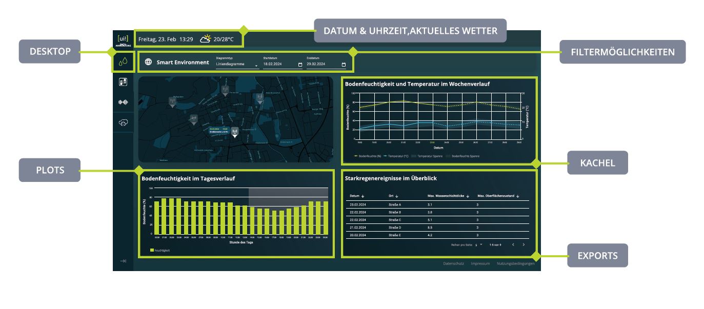
  • Umwelt-Messdaten: Für diesen Use Case bieten wir Ihnen gleich mehrere zur Verfügung stehende Kacheln an.
  • Smart Waste: Es können intelligente Müllbehälter vom Typ „Big Belly“ oder „Mr. Fill“ angebunden werden.
  • Lärmbelastung: Für diesen Use Case können Sensoren integriert werden, die die Lärmbelastung stetig erfassen. Diese werden auf einer Kachel übersichtlich dargestellt.
  • Hochwasserschutz: Für den Use Case Hochwasserschutz steht eine Kachel zur Verfügung, über die sowohl Bürger als auch Entscheider stetig den aktuellen Pegelstand einsehen können.

Energieeffizienz

  • Ladeinfrastruktur: Die Ladesäulen eines Anbieters können integriert werden. Für den Anbieter muss bereits ein passender Konnektor vorliegen.
  • Straßenbeleuchtung: Die Kommunalen Straßenleuchten können integriert und angezeigt werden. Die Leuchten müssen vom gleichen System stammen – hierzu zählen derzeit Schréder Exedra, Philips CityTouch und Schréder Owlet IoT.
  • Astrouhr: Die geplante Einzaltscheit der Straßenbeleuchtung in Abhängigkeit der Sonnenzeiten wird hier grafisch aufbereitet und übersichtlich dargestellt. So kann die Kommune abschätzen, wie viel Strom durch die sonnengesteuerten Schaltzeiten heute ungefährt verbraucht werden wird.
  • Präsenzabhängige Lichtsteuerung: Haben Sie ein Lichtsteuerungssystem installiert, das die Helligkeit präsenzabhängig regelt, können Sie dieses mit [ui!] EASY verbinden und sowohl die aktuelle Helligkeit als auch den zeitlichen Verlauf des Tages im [ui!] COCKPIT darstellen.
  • Energieeinsparung: Ergänzend zur Kachel „Energie-Historie“ können Sie hier die gesamte jährliche eingesparte Energie betrachten. Diese wird dem Vorjahr gegenübergestellt und als gesparte CO2-Äquivalente dargestellt.
  • Solarenergie: Die Leistung einer PV-Anlage variert und hängt natürlich von der verfügbaren Sonneneinstrahlung ab. Mit dieser Kachel können Sie direkt sehen, wie viel die kommunalen und an die Datenplattform angebundenen PV-Anlagen aktuell generieren, sowie die akkumulierte Energie über den Tag.
  • Stadtinformationen: Diese Kachel zeigt Informationen zur Fläche der Stadt, der aktuellen Einwohnerzahl, die Anzahl der Datenquellen und weitere wichtige Kennzahlen an. In der Solution [ui!] EASY ist diese Kachel immer automatisch enthalten.

Mobilität, Verkehr & Parkraumbewirtschaftung

  • Smart Parking: Die prozentuale Belegung von Parkplätzen kann in einer Kachel dargestellt werden. Dazu zählen sowohl On-Street-Parksensoren als auch kameragestützte Systeme, die die Belegung einer Parkfläche erfassen.
  • Parken: Ergänzend zur Kachel „Smart Parking“ können hier verschiedene Parkplätze und deren aktuelle Auslastung integriert werden. Diese werden rotierend dargestellt, sodass der Nutzer den Überblick über alle erfassten und angebundenen Parkplätze der Kommune erhält.
  • Modal Split: Mithilfe der Kachel „Modal Split“ kann visualisiert werden, wie die Verteilung der Modalitäten in der Kommune genutzt wird. Darüber können Fragen der Bürger beantwortet werden, z.B. wie viele Personen den ÖPNV, das Fahrrad oder das eigene Auto nutzen.
  • Ladestationen: Die Belegung mehrere Ladepunkte an einem Standort wird in einer Liste dargestellt. Gleichzeitig wird auch erfasst, ob der zugehörige Parkplatz ebenfalls verfügbar ist. Auf diese Weise können Nutzer bereits vorher sehen, ob sich die Anfahrt zum Ladepunkt lohnt.
  • Digitaler Stadtrundgang: Mit dieser Kachel können Sie Ihre Bürger zu einem digitalen Stadtrundgang einladen. Natürlich kann hier auch eine andere Anwendung verlinkt werden, die den Bürger zu mehr Interaktion einlädt.
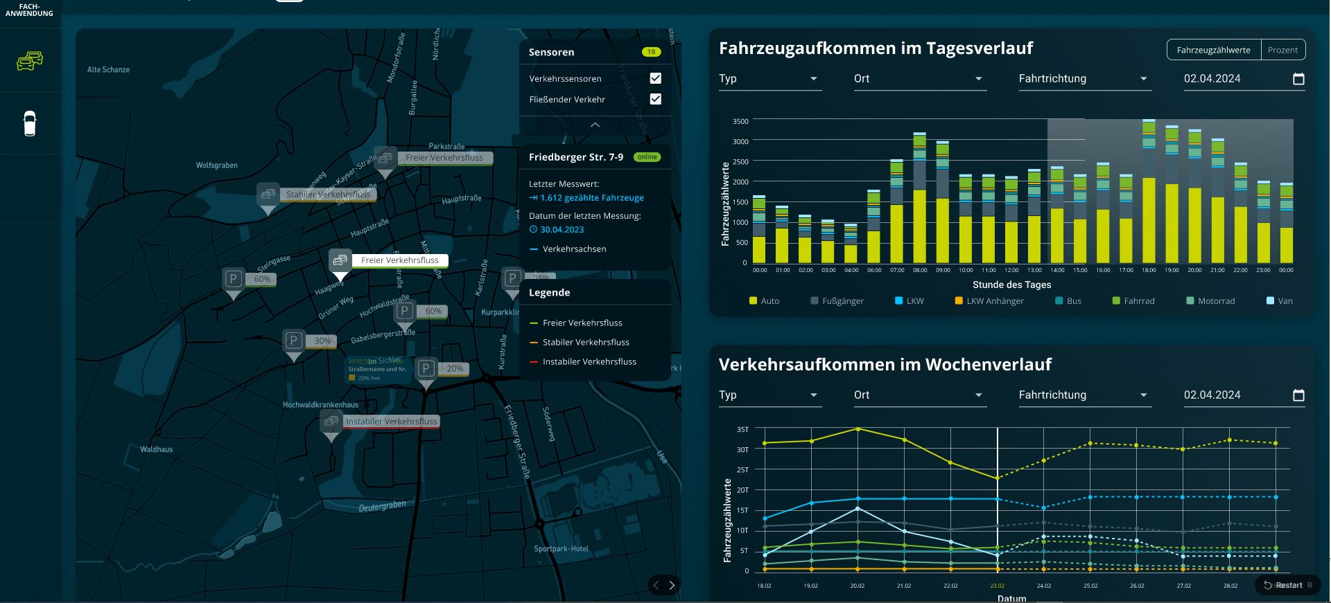
  • Verkehrsüberwachung: Diese Kachel zeigt ihnen auf einen Blick das aktuelle Verkehrsaufkommen sowie die gezählten Fahrzeuge über die letzten 24 Stunden. Sie können sofort Anomalien sehen und sich wiederholende Muster erkennen und diesem ggf. erhöhtem Verkehrsaufkommen mit konkreten und zielgerichteten Maßnahmen zu begegnen.
  • Verkehrsabhängige Lichtregelung: Analog zur präsenzabhängigen Lichtregelung, die primär auf Fußgänger abzielt, lohnt sich natürlich gleichermaßen die Lichtregelung der Straßenbeleuchtung auch an den Verkehr anzupassen. Mit dieser Kachel können Sie sowohl die gezählten Fahrzeuge und damit den aktuellen Verkehr, als auch den zeitlichen Verlauf einsehen.
  • Verkehrsinformationen: Diese Kachel zeigt nutzerfreundlich die aktuellen Baustellen im Gebiet der Kommune an. Durch die Kartenansicht wird diese Kachel perfekt ergänzt, weil Nutzer die aktuellen und sogar geplanten Baustellen direkt auf der Karte verortet einsehen können.


FESTIVAL-COCKPIT

Mittels dem, speziell für große Events entwickelten, [ui!] Festival COCKPIT, können an einem Leitstand in Echtzeit wichtige Daten, wie Zahlen zum Verkehrsaufkommen und zu den Verkehrsgeschwindigkeiten, Wetterdaten, Parkplatzbelegungen, Besucheraufkommen, Temperatur- und Umweltdaten, Abschleppvorgänge und vieles andere gezeigt werden. Somit  haben die Verantwortlichen zu jeder Zeit einen aktuellen Gesamtüberblick und können ggfs. eingreifen.

Sie haben die Möglichkeit sich die Kacheln Ihres COCKPITS selbst zusammen zu stellen. Legen Sie einfach los...

3. [ui!] DATALAB

Kommunales Lagebild mittels KI - als Entscheidungshilfe

Neben der Bereitstellung, der mittels [ui!] UrbanPulse aufbereiteten urbanen Daten für ein öffentliches COCKPIT, können weitere, detailliertere Informationen für die Erstellung eines echtzeitbasierten, kommunalen Lagebildes zur Verbesserung der Entscheidungsfindung in einem [ui!] DATALAB den Entscheidungsträgern zur Verfügung gestellt werden.

Das Visualisierungstool ist skalierbar und gibt dem Nutzer die Möglichkeit, eigene Anfragen und Analysen zu erstellen. Hierbei unterstützen unterschiedliche Visualisierungsarten wie:

  • Liniendiagramme
  • Balkendiagramme
  • Gauge Diagramme
  • Heatmaps
  • 2D-Karten
  • 3D-Karten
  • Datentabellen
  • und mehr...

Weitere Filtermöglichkeiten sind:

  • Datums und Uhrzeitfilter
  • Schieberegler
  • Auswahlfilter
  • und mehr...

Prognosen

Für eine große Auswahl an Datenquellen bieten wir automatisierte, zeitreihenbasierte Prognoseservices auf Basis Künstlicher Intelligenz an. Prognosehorizonte sind bis zu einer Woche in die Zukunft. Prognosen ergänzen historische Daten in einer Art, die Sie vom Reagieren ins Agieren für unterschiedliche Anwendungsfälle versetzen können.

Handlungsempfehlungen

Basierend auf den Datenanalysen von [ui!] erhalten Sie Handlungsempfehlungen in natürlicher Sprache oder mit grafischen Komponenten.

  • Datalab Traffic

  • Datalab Environment

Zum [ui!] DATALAB Katalog mit Funktionsbausteinen

Unsere Produkte & Lösungsansätze im Überblick


  • [ui!] UrbanPulse

    Maximieren Sie den Nutzen Ihrer kommunalen Daten

    Mit der Offenen Urbanen Datenplattform [ui!] UrbanPulse können Sie Ihre vorhandenen und neuen kommunalen Daten effizient sammeln, analysieren und aufbereiten. So erhalten Sie stets einen aktuellen Überblick über Ihre Kommune, der als Grundlage für fundierte Entscheidungen bei der Bewältigung anstehender Herausforderungen dient.

    Weitere Details

  • [ui!] COCKPIT

    Kommunale Daten intelligent und öffentlich visualisieren

    Mit dem [ui!] COCKPIT können Sie Ihren Bürgern auf einer öffentlich zugänglichen Webplattform anschaulich zeigen, wie Ihre Kommune smarte Datenlösungen u.a. in den Bereichen Umwelt, Mobilität, Verkehr, Parkraummanagement, E-Ladestationen nutzt. Machen Sie sichtbar, wie Ihre Kommune durch innovative Technologien smarter wird.

    Weitere Details

  • [ui!] DATALAB

    Datenbasierte Entscheidungsgrundlagen in Echtzeit erstellen

    Das skalierbare Visualisierungstool [ui!] DATALAB ermöglicht es Ihnen, auf Basis Ihrer vorhandenen Daten eigene Abfragen und Analysen in Echtzeit zu erstellen. Nutzen Sie diese fundierten Erkenntnisse als wertvolle Unterstützung für Ihre kommunalen Entscheidungsträger.

    Weitere Details

  • [ui!] ENVIRONMENT

    Fundierte Entscheidungen für eine nachhaltige Umwelt

    Mit [ui!] ENVIRONMENT erfassen Sie Umweltdaten wie Bodenfeuchte, Luftqualität, Wasserstände oder Lärmbelastung, um die aktuelle Umweltsituation in Ihrer Kommune zu überwachen. Treffen Sie auf dieser Grundlage gezielte Entscheidungen, um eine gesunde und saubere Umwelt für zukünftige Generationen zu sichern.

    Weitere Details

  • [ui!] TRAFFIC

    Optimieren Sie Ihre Verkehrsplanung mit präzisen Bewegungsdaten

    Nutzen Sie echte Bewegungsdaten von Verkehrsteilnehmern, um den Verkehrsfluss in Ihrer Kommune zu verbessern. Durch die Analyse von Fahrzeugpositionsdaten (Floating Car Data, FCD) können Sie Engpässe im Straßennetz identifizieren und gezielt Maßnahmen zur Verbesserung des Verkehrsflusses ergreifen.

    Weitere Details

  • [ui!] PARKING

    Intelligente Parkraumbewirtschaftung für Ihre Kommune

    Bewältigen Sie die Herausforderungen des Parkraummanagements mit einer datenbasierten Lösung, die es Ihnen ermöglicht, die Parkaktivitäten zu überwachen, die Infrastruktur optimal zu planen und den Parkverkehr effizient zu lenken. Reduzieren Sie so den Parksuchverkehr und entlasten Sie Ihre Anwohner.

    Weitere Details

  • [ui!] CLIMATE

    Machen Sie Ihre Klimainitiativen sichtbar und wirksam

    Machen Sie die Anstrengungen Ihrer Kommune für eine nachhaltige Umwelt transparent. Entwickeln Sie konkrete und nachhaltige Maßnahmen, um eine gesunde und saubere Umwelt zu sichern und einen hohen Lebensstandard für Ihre Bürgerinnen und Bürger zu erhalten.

    Weitere Details

  • [ui!] M2CHARGE

    Skalierbare Komplettlösung für den Betrieb von Elektrotankstellen

    Betreiber von E-Ladestationen erhalten eine umfassende Lösung, die Funktionen wie Billing & Payment, Roaming und Smart Charging bietet. Starten Sie klein und skalieren Sie Ihre Ladeinfrastruktur einfach mit Ihren wachsenden Anforderungen.

    Weitere Details

  • [ui!] EASY

    Der leichte Einstieg in die digitale Transformation

    Mit dem [ui!] EASY Starterpaket machen Sie die ersten Schritte in die Digitalisierung Ihrer Kommune. Die Software-as-a-Service (SaaS)-Lösung bietet Ihnen alle Vorteile der Offenen Urbanen Datenplattform [ui!] UrbanPulse. Testen Sie innerhalb von 12 Monaten bis zu drei Anwendungsfälle mit der Anbindung von bis zu 20 Sensoren und legen Sie den Grundstein für weitere digitale Projekte.

    Weitere Details

Referenzen

Forschung & Entwicklung


Wetterbasierter Echtzeit-Routenführung für Outdoor-Aktivitäten

Sicher unterwegs

Mit unserer Lösung für wetterbasierte Echtzeit-Routenführung werden Outdoor-Routen sicherer, intelligenter und nutzerfreundlicher. Die Anwendung bewertet Risiken abschnittsgenau und dynamisch – auf Basis von Wetterinformationen, Geländedaten, Routendaten und Umfelddaten. So entstehen nicht nur statische Routenvorschläge, sondern situationsbezogene Empfehlungen, die die aktuellen Bedingungen auf der Strecke aktiv mit einbeziehen.

Bei erhöhter Gefahr warnt die Anwendung in Echtzeit und empfiehlt sichere Alternativen oder ein angepasstes Ziel. Nutzerinnen und Nutzer erhalten damit genau dann Orientierung, wenn sie unterwegs wirklich gebraucht wird – etwa bei Wetterumschwüngen und sich plötzlich veränderten Bedingungen entlang der Route. Das erhöht die Sicherheit, verbessert die Planbarkeit und schafft mehr Vertrauen in digitale Outdoor-Navigation.

Die Lösung ist so angelegt, dass sie sich flexibel in bestehende digitale Angebote integrieren lässt – zum Beispiel in Outdoor-Apps, Tourismusplattformen, Kartenanwendungen, Geräte oder digitale Destination-Informationen. Informationen können über interaktive Karten, mobile Anwendungen und weitere digitale Kanäle bereitgestellt werden und erreichen Nutzer sowohl bei der Tourenplanung als auch direkt unterwegs.

Für Nutzer bedeutet das mehr Orientierung, Sicherheit und ein insgesamt entspannteres Outdoor-Erlebnis. Für Anbieter entsteht ein differenzierendes Premium-Feature, mit dem sich Outdoor-, Tourismus- und Navigationsangebote gezielt aufwerten lassen. Gleichzeitig eröffnet die Lösung neue Möglichkeiten, digitale Services in Destinationen weiterzuentwickeln und Besuchern einen spürbaren Mehrwert zu bieten.

wetterabhangige Routenklassifzierung in Echtzeit modal  Gesamte Karte mit Index ansehen

Sie haben noch weitere Fragen?

Hier finden Sie möglicherweise bereits einige Antworten auf Fragen, wenn nicht - melden Sie sich, wir stehen Ihnen jederzeit für Ihre Anliegen zur Verfügung.

Schreiben Sie uns

Brief2 This email address is being protected from spambots. You need JavaScript enabled to view it.

Read more …Solutions

Our approach:
an open urban data platform
as the basis for your smart city strategy

So that you can master urban challenges.


  • Where does the data come from?

    [ui!] Urban Lighting Innovations

    cThe digital infrastructure of cities, municipalities and districts collects numerous data using sensor systems, such as intelligent street lighting or traffic lights.

  • Collecting data with connectors

    [ui!] Urban Software Institute

    cThe data collected is gathered using a variety of connectors and forwarded to the urban data platform [ui!] UrbanPulse. This allows a wide variety of IT systems to be linked together.

  • Use of connectors

    [ui!] Urban Software Institute

    The data collected is gathered using a variety of connectors and forwarded to the urban data platform [ui!] UrbanPulse.

    There are already a large number of connectors, but more can be developed by you or by us.

  • [ui!] UrbanPulse as the basis of your digitalisation strategy

    [ui!] Urban Software Institute

    In order to be able to implement the digitalisation of cities, municipalities and districts, an open urban real-time sensor data platform such as [ui!] UrbanPulse is a basic prerequisite for success.

    [ui!] UrbanPulse collects all the information from sensor systems and external providers and gives you the opportunity to decide which of the data you want to process and to whom you want to make it available for further processing.

  • Visualisation of your data with [ui!] COCKPIT

    [ui!] Urban Software Institute

    Once you have selected the data that you would like to use, you can also make it available to your citizens via a [ui!] COCKPIT in order to enter into dialogue and transparently demonstrate the benefits of the data collected.

  • Intelligent services as added value

    [ui!] ULI, [ui!] UMI,

    Using the data collected and processed on [ui!] UrbanPulse, third-party providers can offer their services in the same way as you as a city, municipality or district and thus provide added value for your citizens.

    A fee can also be charged for the provision of the processed data, enabling new business models for local authorities.

  • Your data pulse

    [ui!] Urban Software Institute

    The pulse used on numerous [ui!] COCKPITs stands for the continuously collected and processed information of a city, municipality or district. The stronger it is and the more dark green its colour, the more frequently high-quality measurements are taken and passed on to the [ui!] UrbanPulse open data platform.

[ui!] Approach


How can you promote digitalization in your community?

We support cities, communities, counties and regions in their efforts to collect, process and analyze all existing and anonymized urban data on a central data platform. We also help make this data available for new services as added value for cities, community and utility companies.

These solutions are based on an open urban data platform - the [ui!] UrbanPulse - where all data from a city's various IT systems are fed into a multitude of connectors, in order to be used for new smart city services in real-time.

[ui!] UrbanPulse enables the transparent visualization of all information about a city and makes it available for further use. The data sovereignty always remains with the client, for whom the data is being collected. The platform, therefore, not only provides integrated access to urban data, but it also prevents the risk of data misuse.

Data is not equal to data


The benefit of data, as well as its possible uses, depend largely on its degree of refinement. While raw data is merely a disorganized mass of data from which no direct conclusions can be drawn, structured data as information already lays the foundation for data analysis, from which concrete knowledge for new innovative services, as an added value for citizens, ultimately emerges.

Digital data as the basis for new value creation

raw materials for new beneficial services in the areas:

  • Traffic lights
  • Real-time geodata from public transport and railways
  • Integrated multifunctional street lighting
  • Real-time geodata from sharing providers (car, eBike, bicycle, eScooter)
  • Floating Car Data of vehicle fleets
  • APP-based geodata

Economic cycle "Digital data streams"

Creating "smart data" using platforms that have the following characteristics:

  • Low latency
  • Forecasting ability
  • Openness
  • Security
  • Standardized

What does data sovereignty mean?

As an owner of large amounts of urban data, you should ensure your data sovereignty with an integrated, open and real-time data platform, including the organization of analysis tools. This gives you an overview of all your data and its use at all times.

Existing and new urban data can therefore be used to create new benefits for your citizens.

Would you like to know more about our philosophy and [ui!] UrbanPulse?

We are also available for demonstrations at our branches in Berlin, Darmstadt, Munich, Walldorf or Chemnitz.

Read more …Our approach

Currently, cities, districts, communities and regions have numerous challenges to overcome in the progress of digitization.

Advancing urbanization and the associated challenges, including infrastructure, mobility and energy, require a new, networked approach.

On the one hand we have resource-conservation and environmentally compatible action, and on the other hand situation-specific and appropriate decision-making, both require extensive data from many previously isolated systems.

A rethinking of consumption, resources and the environment is more important than ever. However, this requires a lot of data. This data must be collected, processed, visualized and further used to address the following issues, among others:

"Smart Cities & Smart Regions are committed to sustainable & integrated urban development"

[ SMART CITY CHARTER ]

The digital transformation offers cities, districts, communities and regions opportunities on the path to sustainable development and aims at the resource-saving, demand-oriented solution of the central challenges of urban development.

* The Smart City Charter supports the implementation of the German Sustainability Strategy and the realisation of the global sustainability goals of the United Nations' Agenda 2030 (Sustainable Development Goals).

What is Digital Transformation?

Digital transformation

Digitalization will continue to change many areas of administration, economy and urban society.

Digital change and adaptation process to a socially acceptable, fair, energy- and resource-efficient smart city, district, community and region

To this end, information and communication technologies are used to link municipal infrastructures, such as energy, buildings, transport, water and wastewater on the basis of integrated development concepts.

Source: Smart City Charta - bmi.bund.de

We support you in your digital transformation!

We are also available for demonstrations at our branches in Berlin, Darmstadt, Munich, Walldorf or Chemnitz.

Contact us

Would you like to know more about our solutions?

Brief2 This email address is being protected from spambots. You need JavaScript enabled to view it.

Berlin: +49 (0) 30 208 47 24 40
Darmstadt: +49 (0) 371 8 57 98 59
Munich: +49 (0) 89 6931495 40

  • 52.5046,13.3277

    Berlin

    Fasanenstraße 3
    D- 10623 Berlin
    T +49 (0) 30 208 47 24 40

  • 50.8194,12.8755

    Chemnitz

    Zwickauer Straße 223a
    D- 09116 Chemnitz
    T +49 (0) 371 8 57 98 59

  • 50.1468,8.66828

    Darmstadt

    Rössler Str. 88
    D- 64293 Darmstadt
    T +49 (0) 6151 4 93 20 60

  • 48.2673,11.6672

    München

    c/o BASE
    Blütenstr. 15
    80799 München
    T +49 (0) 89 54 84 20 95

  • 49.3011,8.64839

    Walldorf

    Haydnstraße 34
    D- 69190 Walldorf
    T +49 (0) 6151 49 320 60

Use Cases

Solutions

[ui!]

Links

© [ui!] Urban Software Institute. All Rights reserved

Read more …Challenge

We are at your disposal
and are looking forward to your visit!

Visit us in one of our [ui!] offices

  • 50.8194,12.8755

    Chemnitz

    Zwickauer Straße 223a
    D- 09116 Chemnitz
    T +49 (0) 371 8 57 98 59

  • 50.1468,8.66828

    Darmstadt

    Rössler Str. 88
    D- 64293 Darmstadt
    T +49 (0) 6151 4 93 20 60

  • 48.2673,11.6672

    München

    c/o BASE
    Blütenstr. 15
    80799 München
    T +49 (0) 89 6931495 40

  • 49.3011,8.64839

    Walldorf

    Haydnstraße 34
    D- 69190 Walldorf
    T +49 (0) 6151 49 320 60

  • -26.3587,152.9948

    Australien

    [ui!] The Urban Institute Pty Ltd

    c/o Innovation Centre, 90 Sippy Downs Drive
    Sippy Downs QLD
    4556 Australia
    T: +61 7 5457 0307

  • 47.4984,19.0404

    Hungary

    [ui!] urban institute Hungary Zrt.

    Egry József u. 18, V1 Building C wing.
    Budapest, 1111,
    Budapest University of Technology and Economics
    T +36 1 463 34 19

  • 40.7143,-74.006

    USA

    [ui!] urban integrated inc.

    One World Trade Center
    285 Fulton Street, Suite 8500
    New York, NY 10007

  • Chemnitz

    Zwickauer Straße 223a
    D- 09116 Chemnitz
    This email address is being protected from spambots. You need JavaScript enabled to view it.

  • Darmstadt

    Rössler Str. 88
    D- 64293 Darmstadt
    This email address is being protected from spambots. You need JavaScript enabled to view it.

  • München

    c/o BASE
    Blütenstr. 15
    80799 München
    T +49 (0) 152 53 66 87 79
    This email address is being protected from spambots. You need JavaScript enabled to view it.

  • Walldorf

    Haydnstraße 34
    D- 69190 Walldorf
    This email address is being protected from spambots. You need JavaScript enabled to view it.

  • [ui!] Urban Lighting Innovations

    Werner-von-Siemens-Str. 2-6
    Gebäude 5161
    D-76646 Bruchsal

  • [ui!] Urban Mobility Innovations

    c/o BASE
    Blütenstr. 15
    80799 München
    This email address is being protected from spambots. You need JavaScript enabled to view it.

  • [ui!] Urban Software Institute

    Zwickauer Straße 223a
    D- 09116 Chemnitz
    This email address is being protected from spambots. You need JavaScript enabled to view it.

  • [ui!] The Urban Institute Pty Ltd

    Australia

    c/o Innovation Centre, 90 Sippy Downs Drive
    Sippy Downs QLD
    4556 Australia

    E: This email address is being protected from spambots. You need JavaScript enabled to view it.

  • [ui!] urban institute Hungary Zrt.

    Hungary

    Egry József u. 18, V1 Building C wing.
    Budapest, 1111,
    Budapest University of Technology and Economics

    E: This email address is being protected from spambots. You need JavaScript enabled to view it.

  • [ui!] urban integrated inc.

    USA

    8 The Green #12694
    Dover, DE 19901 - USA
    E: This email address is being protected from spambots. You need JavaScript enabled to view it.

Read more …Contact


The [ui!] Company group


Prof. Dr. Dr. e.h. Lutz Heuser
CEO & Co-Founder of [ui!]
The [ui!] GROUP is a synergy of the three divisions:
  • Software development - [ui!] Urban Software Institute,
  • Urban infrastructures - [ui!] Urban Lighting Innovations.
  • Sustainable mobility concepts - [ui!] Urban Mobility Innovations (B2M)
and its subsidiaries in Australia, the United Kingdom, Hungary and the USA.

[ui!] is worldwide active and advises municipalities, cities and metropolitan regions in their strategic planning to implement ambitious climate targets, optimize existing and expand with new urban infrastructure, a more sustainable mobility concept and new energy concepts in urban areas. Energy suppliers as well as municipal and private companies are customers and partners when it comes to the implementation and operation of Smart City infrastructures.

Founded with the charter to closely accompany the European innovation partnership "Smart Cities and Communities", the [ui!] GROUP supports cities, districts and regions worldwide on their way to reach the set climate protection goals with the support of digitalization as well as innovative concepts and solutions.

Climate protection, citizen benefits and economically successful services and solutions are not mutually exclusive, but complement each other to form a sustainable alliance for the future of urban space.

Therefore the companies of the [ui!] GROUP focus on cloud-based services in the following areas:
  • Open Urban Data Platform as the basis for digital transformation
  • Sustainable urban and interregional mobility
  • Low-emission, optimized traffic
  • Integrated street lighting
  • Energy management for urban quarters
  • Integrated urban infrastructures

The Concept


[ui!] was founded in 2012 to support cities in their efforts to jointly develop innovative concepts and solutions in the sense of data sovereignty for intelligent communities and regions and to use them sensibly.
Today, the [ui!] Group consists of five locations in Germany and offices in Brisbane (Australia), Budapest (Hungary), Oxford (UK) and New York (USA).

Our Strengths


The focus of our activities is on cloud-based Smart Services to provide existing urban real-time data from Open Urban Data Platforms, urban infrastructure (intelligent street lighting, environmental sensor technology), sustainable mobility, intelligent energy management and other urban data as added value for residents.

Our Customers


We support cities, districts, communities and regions on the way to SMART CITY / SMART REGION. From the first idea to the realisation we are at your side as a competent partner and can draw from an extensive collection of blueprints and the associated experience in implementation. With this collected knowledge we can advise you holistically and are at your disposal as "Trusted Advisor".

Our sustainability strategy

The Urban Software Institute, a pioneer in the development and implementation of Smart City/Smart Region solutions, is determined to achieve carbon neutrality by 2035.

This goal, which stems from both our fundamental responsibility to the environment and our desire to have a positive impact on society, is at the core of our corporate philosophy.

In a world that is increasingly facing the challenges of climate change and sustainability, we see it as our responsibility to contribute to environmental protection not only through our products and services, but also through our operations and corporate culture.

It was therefore a matter of course for us to sign the Charter for Sustainable Management of the State of Hesse.

We have already made significant progress in our efforts to reduce our company's carbon footprint. By implementing energy-efficient technologies and systems in our offices and production facilities, we have been able to significantly reduce our energy consumption.

In addition, we have placed an emphasis on environmental friendliness in the development of our software products, not only to reduce our own emissions, but also to help our customers minimize their environmental impact.

Through our close cooperation with over 100 municipalities in the development and implementation of use cases for traffic flow analysis and optimization, we have also made a significant contribution to reducing emissions in urban areas.

Charta Nachhaltiges Wirtschaften
  • Strategic goals

    Short-term goals

    Over the next few years, we plan to further optimise our internal processes in order to reduce our CO2 emissions. In doing so, we are focussing on increasing our energy efficiency and reducing energy consumption in our offices.

    At the same time, we are working on the development and implementation of new software solutions aimed at helping our customers - especially local authorities - to reduce their CO2 emissions. These solutions should enable our customers to achieve their environmental goals more efficiently and effectively.

    Medium-term goals

    We have set ourselves the goal of significantly increasing the proportion of renewable energy in our total energy consumption. This includes covering our energy needs from solar energy, wind energy and other sustainable energy sources in order to reduce our dependence on fossil fuels.

    Another focus in the coming years will be the expansion of our product range to include specialised solutions designed to help our customers on their path to carbon neutrality. This includes the development of tools and applications that are tailored to the specific needs and challenges of cities and municipalities.

    Long-term goals

    Our long-term goal is to achieve complete CO2 neutrality for our company by 2035. This includes offsetting any remaining emissions through innovative methods such as carbon capture and storage or investing in environmental protection projects.

    In addition, we aim to further consolidate and expand our position as a leading provider of carbon-neutral smart city/smart region solutions. This includes the continuous development of our products and services and the expansion of our market presence.

    Measures to reduce CO2 emissions

    Internal measures

    Energy efficiency and renewable energy: A key component of our internal efforts to reduce CO2 emissions is the implementation and promotion of energy efficiency and the use of renewable energy sources. We have already invested in a variety of measures to lower our energy consumption and reduce our dependence on fossil fuels. This includes the installation of energy-efficient lighting, the optimization of our operational processes and the use of renewable energy sources such as solar energy.

    Promoting electric mobility: As part of our commitment to a sustainable future, we have started to convert our company fleet to electric vehicles. This process will continue over the next few years, with the aim of establishing a fully electric company fleet by 2027. We are also promoting the use of electric vehicles among our employees by providing charging facilities at our sites and creating incentives for the use of electric mobility. The same applies to the use of company bicycles and e-bikes.

    Optimization of operational processes: Another important aspect of our internal measures to reduce CO2 emissions is the optimization of our operational processes. By using artificial intelligence and machine learning, we have adapted our processes to make them more efficient and environmentally friendly. This includes reducing energy consumption, minimizing waste and optimizing our travel activities. We promote the use of home office to support a healthy work-life balance for our employees and at the same time significantly reduce the number of trips since the Covid pandemic.

    External measures

    CO2-reducing software solutions for municipalities: A central component of our external efforts to reduce CO2 is the development and implementation of software solutions aimed at reducing our customers' CO2 emissions. Our products, such as the [ui!] UrbanPulse and the [ui!] COCKPIT, are continuously being developed to support municipalities in effectively reducing their emissions. We focus on solutions that make urban traffic, parking management, electromobility and urban infrastructure more efficient.

    Consulting and support for municipalities: In addition to developing software products, we also offer comprehensive consulting services to support cities and municipalities in implementing sustainable measures. These services include consulting in the areas of traffic management, electromobility, energy efficiency and CO2 reduction. We offer training courses and workshops to train municipal staff in the effective use of our software products and support them in planning and implementing measures to reduce CO2 emissions.

    Technology and innovation

    As a technology company, our focus is on the development and implementation of innovative solutions that make a positive contribution to environmental protection. Our commitment to research and development enables us to constantly develop new and improved solutions to the challenges of climate change. We are committed to developing the next generation of smart city/smart region solutions that are even more efficient and effective in reducing CO2 emissions. This includes the continuous improvement of our existing products as well as the development of new technologies and applications specifically designed to minimise the environmental impact of our customers.

  • Employee engagement and training

    Commitment to sustainability

    Employees are at the heart of the Urban Software Institute GmbH, and their commitment is crucial to the success of our sustainability strategy. We recognise that sustainable change must start from within. Therefore, our goal is to create an environment in which every employee feels responsible for and actively contributes to the reduction of CO2 emissions.

    Training programmes

    To promote this commitment, we have introduced extensive training programmes. These programmes are designed to raise awareness of environmental issues and develop the skills of our employees with regard to sustainable practices. From workshops on environmental protection to training in energy-efficient technologies and resource management - we cover a broad spectrum.

    Innovation promotion

    We encourage our employees to develop and implement innovative ideas on sustainability. To this end, we organise regular ideas competitions in which teams can develop solutions to specific environmental problems. These initiatives not only strengthen the commitment of our employees, but also promote the creation of new, innovative solutions that advance our company and our customers. We pay particular attention to co-operative innovation within the framework of joint projects, in which we focus primarily on sustainability and climate protection issues.

  • Partnerships and cooperation

    Network development

    Partnerships are invaluable in the field of sustainability. We work closely with a wide range of stakeholders, including cities, municipalities, industry partners and research organisations. This collaboration allows us to utilise a broader range of knowledge and resources to develop innovative solutions to the challenges of climate change.

    Co-operation with municipalities

    Our partnerships with local authorities are particularly important. By jointly developing and implementing smart city solutions, we contribute directly to reducing CO2 emissions in urban areas. We are committed to deepening and expanding these partnerships in order to achieve even greater impact.

    Research and development

    Cooperation with research institutions enables us to remain at the forefront of technological development. We work together to research and develop new technologies and approaches to achieve our sustainability goals.

    Monitoring and reporting

    An effective monitoring system is crucial to measuring the progress of our sustainability efforts. We have implemented a comprehensive system that enables us to closely monitor and assess our CO2 emissions.

    Transparent reporting

    Transparency is a key element of our sustainability strategy. We regularly report on our progress, challenges and successes. This includes not only internal reports, but also the publication of information for our stakeholders and the public.

    Commitment of our customers

    We also record and report on our customers' success in reducing their CO2 emissions. This data shows how our products and services contribute to achieving climate targets and helps us to continuously improve our strategies.

  • Financing and investment

    Investing in sustainability

    Financing our sustainability initiatives is a key aspect of our strategy. We make targeted investments in technologies and projects that support our CO2 reduction targets.

    Utilisation of subsidies

    To support these investments, we make use of a variety of funding programmes and subsidies. These funds enable us to realise innovative projects that would not be possible without this financial support.

    Long-term financial planning

    We do not see sustainability as a cost factor, but as an investment in the future of our company and our society. The integration of sustainability financing into our long-term financial planning is therefore a decisive step.

  • Conclusion and outlook

    Vision of CO2 neutrality

    Our comprehensive sustainability strategy reflects our commitment to being a carbon-neutral organisation by 2035. This strategy is deeply rooted in our corporate mission and vision and is an essential part of our identity as a leading provider of smart city/smart region solutions.

    Continuous improvement

    We endeavour to continuously improve and adapt our strategies to meet changing requirements and challenges. Our journey to carbon neutrality is an ongoing process that requires commitment, innovation and collaboration.

    Contributing to a sustainable future

    In conclusion, we are convinced that our commitment to sustainability will not only lead to a reduction in CO2 emissions, but will also help to create a more liveable, healthier and more sustainable future for all. We are proud to be a leader in this crucial area and look forward to continuing on this path together with our employees, partners and customers.

We have already received numerous awards for our solutions and activities in the Smart City area.

Awards


  • Digitization and climate protection project in Bad Hersfeld inspires Smart 50 jury in the USA

    Ui-as-a-Service

    Digitization and climate protection project in Bad Hersfeld inspires Smart 50 jury in the USA

    Street lighting project in Bad Hersfeld wins international Smart City Award!

    The " SMART LIGHTING as a Service" project, which is currently running in Bad Hersfeld, was selected from a large selection of worldwide applicants as the winner of this year's Smart 50 Award.

    AwardSiegelThe Smart 50 Awards of the internationally renowned organization "Smart Cities Connect" is awarded annually for global, innovative smart city projects and aims to honor some of the most influential projects and forward-looking ideas in the context of smart city and smart region.

    Our now award-winning project "SMART LIGHTING as a Service" is being implemented for the citizens of the city of Bad Hersfeld in collaboration with [ui!] Urban Lighting Innovations in cooperation with the luminaire manufacturer Schréder, Deutsche Bank and Microsoft. Our new, innovative product "URBAN INTELLIGENCE as a Service" ([ui!] UIaaS) is used here.

    Mayor Thomas Fehling is delighted about the award: "Only two European projects made it to the final selection, and only one came from Germany - ours. The fact that an international jury of experts has now recognized our innovative approaches makes the project partners and me very grateful."

    The aim of the Bad Hersfeld pilot project is to test and implement new approaches for future street lighting. Requirements for lighting design in public spaces, some of which are contradictory, such as cost savings, energy efficiency, (traffic) safety, insect-friendliness or climate protection, will be " reconciled" better than before.

    Bad Hersfeld ZylindoOn the one hand, this includes the latest generation of luminaires, which will be permanently installed in Bad Hersfeld. Secondly, there will be intelligent digital lighting control, which will use sensors and artificial intelligence to make one and the same range of luminaires suitable for very different areas of application. "We need very different light in residential areas or in outdoor areas of the city that are close to nature than on our main roads, for example," says Fehling. "If we can use the project to create opportunities to better control light in the future in the necessary brightness and color temperature or adapted to the weather or season at the locations, that would not only be an improvement in terms of quality, but also very interesting economically."

    Since the Bad Hersfeld pilot project is "breaking new ground worldwide" due to its innovative nature, Fehling sees no contradiction in the fact that the local project is already receiving an award - even though it has not yet been completed.

    "Even though we don't yet have all the answers, the Smart 50 Award gives us confirmation from other experts that we have at least asked the right questions about the street lighting of the future. Our results from the last few months make us confident that there really is "still a lot to be done" in this area."

    With the new development of [ui!] UIaaS, [ui!] Urban Lighting Innovations has realized a solution that allows citizens to control brightness, color temperature and photometric light distribution dynamically via an app individually and thereby sustainably fulfills the recommendations of the German Federal Ministry for the Environment, Nature Conservation and Nuclear Safety (BMU).

    The Smart Street Lighting project has been implemented since July 2021 and will last one year to capture all weather and seasonal requirements for public lighting. So the results can be expected this summer.

    UIaaS is the key component here, which will also serve in the development of many other smart cities and regions. We are pleased to be among the winners of the Smart 50 Award this year, together with our cooperation partners and the city of Bad Hersfeld, and see this award as a confirmation of the joint efforts of the city of Bad Hersfeld, Deutsche Bank, Microsoft and [ui!] to make a sustainable contribution to climate protection, energy efficiency and environmental protection in the shortest possible time.

    More info about the award: https://spring.smartcitiesconnect.org/Smart50Awards/

  • Smart 50 Awards of the Smart City Connect conference

  • Top 5 start-up for urban Mobility

  • Digital Leader Award mit Köln - 2017

  • Digital Leader Award mit Darmstadt - 2016

  • Best paper award for eMaaS (eMaaS - Electric Mobility as a Service)

  • Best scientific contribution

  • Mobisaar - Top Ten of Mobility for all

  • Top 25 - Promising Smart City Solution Provider

Cooperation Partner


  • Wilo

  • FIWARE

Research Partner


  • QUT

  • Uni Budapest

  • Kit

Networking


Would you like to know more about our solutions?

Brief2 This email address is being protected from spambots. You need JavaScript enabled to view it.

Read more …About [ui!]